Add your own picture and explain the route, parking, gates, paths or landmarks that help people find it.
Earn 5 points after the picture is checked and accepted.
Add your photo and local directionsShare what you foundWhat is recorded here
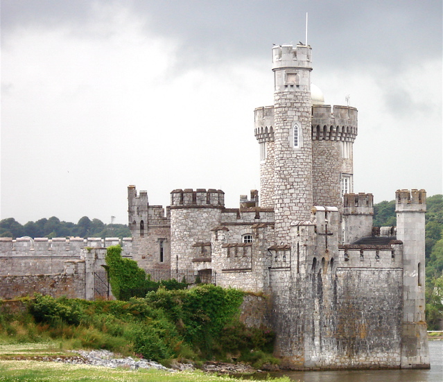
At tip of low limestone projection, on S shore of river Lee; circular tower (diam. c. 10.5m), now surviving to two storeys; built directly on rock outcrop and now at N end of complex built 1828-9 (Coleman 1914, 175). Exterior face not visible ENE->WSW where later building abuts tower. round floor (int. diam. 6m) entered from base of spiral stairs through intelled doorway to S; now used as store. Evenly spaced, double-splayed embrasures to NE, N, NW, W and SW; latter ope smaller than other four which appear similar; all now blocked up at narrowest point (c. 0.85 from outsid eedge; c. 1.5m from inside edge; wth c. 0.6m). Inside of embrasures (wth1.75m) covered by plank-centred segmental arch (H c. 1.85m), base at floor level; outside covered by upward inclined lintels with downward inclined sill and splayed sides (max. H c. 0.75m; max. wth 1.2m). Recent roof now covers ground floor, but stone corbels indicate lower level of original wooden roof.
First floor chamber now part of bar/restraunt. Door from spiral stairs blocked and room now entered through recent doorway to S. Five evenly-spaced embrasures, off-set with ground floor opes, covered by segmental arches. Three central embrasures adopted to take window frames; embrasure to E has outer half blocked; embrasure to W has front part ivided by horizontal slab, below is splayed ope similar to those at ground level, now blocked; above is squat round-headed light. Stone corbels indicate level of original wooden roof.
Ground floor embrasures purpose-built gun ports; opes at first floor probably had similar function. Original tower ends at this height with plain cornice course but 18th century paintings show it standing at least two stories higher (Coleman 1914, facing 168; Coleman 1915, facing 1); these show 'handsome octagon room' (Smith 1750, vol 1, 358) atop tower and abutting tower to S gable-ended two-storey house, both of 18th century appearance. Present complex entered through embatteled gateway to S, with stone plaque recording 1828-9 rebuilding of entire complex to design of James and G.R. Pain, in neo-Gothic style; courtyard flanked by further embatteled buildings to W and S with stone wall to E; to S original circular tower, now surmounted by slimmer tower rising a further three storeys with slender turret attached containing spiral stairs (presumably rebuilt upwards from first floor level in 19th century); on E side of tower elaborate water-gate leading to slipway.
Built c. 1582 by citizens of Cork 'with artillery to resist pirates and other invaders' (Flood 1915, 102; Hayes-McCoy 1964, 32); sometimes mistakenly ascribed to Mountjoy (Smith 1750, vol 1, 358; Lewis 1837, vol. 1, 208 (Lewis gives date 1604); Coleman 1914, 169). Rare Irish example of circular tower built for cannon. Used throughout 18th and 19th centuries by Cork Corporation for entertaining and functions.
Built into external 1st floor wall of circular tower, in foyer of bar/restraunt, is fireplace removed here from Ronayn's Court (CO074-059---); large lintel with shallow elliptical arch cut on underside and edge roll moulding carried down jambs, topped by projecting cornice. Lintel bears the inscription "Morris Ronayn and Margaret Gould builded this house in the yeare of oure lorde 1627 and in the 3 yeare of Kinge Charles. Love god and neighbors"; centrally placed monogram "IHS", flanked by family armorial shields; also fleurs-de-lis and tudor rose (rubbing of inscription JCHAS 1912, facing 81).
The above description is derived from the published 'Archaeological Inventory of County Cork. Volume 2: East and South Cork' (Dublin: Stationery Office, 1994). In certain instances the entries have been revised and updated in the light of recent research.
Date of upload/revision: 14 January 2009
The monument record does not grant public access. Check the route and ask the landowner before entering private land.