Add your own picture and explain the route, parking, gates, paths or landmarks that help people find it.
Earn 5 points after the picture is checked and accepted.
Add your photo and local directionsShare what you foundWhat is recorded here
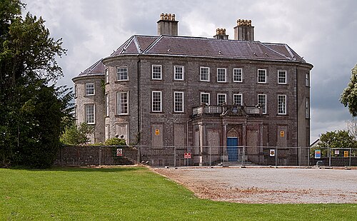
On E side of Doneraile, c. 400m S of site of castle (14304). Built to design of Isaac Rothery for St Leger family c. 1730 but probably incorporating part of earlier house built in 1725 which itself may incorporate part of late-17th century house (Bence-Jones 1978, 105; de Breffny and ffolliott 1975, 91; Grove White 1905-25, vol. 3, 43-7). House restored by Irish Georgian Society and now occupied by caretaker. Entrance front (NE) overlooks parkland with winding approach avenue and Awbeg River. Front 7-bays wide with central 3-bay breakfront; central round-headed door ope with Ionic columns supporting scroll pediment, now incorporated into early 19th-century balustraded porch. Sash windows have moulded surrounds with scroll keystones on two upper storeys; lead fire-plaque dated '1725' above one of upper windows. Bow ends added in late 18th century. House burnt 1805; during reconstruction SE side elevation extended with bow at SW end making garden front (SE) of 3 bays between bow ends. Two-storey dining room, added on NW side in 1869- removed in mid 1980's. Warren of corridors and rooms in basement; brick wine vaults in corner; in 1825 brick arch inserted on S side to contain water tank. Reused stone mullion and jamb stones in basement window of SW bow of SE elevation may have come from nearby castle (14304).
Outbuildings and meat store on SW side of house. Lewis (1837, vol. 1, 478) refers to conservatory built c. 1825; known as the orangery, it had 9 tall window opes in S wall with central masonry wall (portion of which survives) with 3 wide brick arches; partially dismantled c. 1970-76 (pers. comm. A. Montgomery). Walled garden to SW. Farmyard to W with farm building known as 'The Mill'; transmission shaft present in building used as part of horse-powered machinery (pers. comm. A. Montgomery).
Demesne, now part of Doneraile Amenity Park, contains numerous estate features including ha-ha, deer park, 3 bridges over river, impounded ponds, lime walks, tree rings etc. (Crowley 1983). On N side of village is imposing entrance sweep with Ionic entrance archway and gate lodge. Avenue Bridge (long axis N-S; Wth 6.15m) has three semicircular arches (span c. 4m), bluntly pointed breakwaters on upstream side with decorative niches overhead; according to local information, built in 1800. Fish pond/ canal, c. 400m SE of house, described by Smith (1750, 329) as '370 yards long, and 140 broad'. Upper canal supplied by waterwheel, described by Young in 1770s (1892, 306) 'as an improvement on the Persian, which raises a regular stream 28 feet'. Mound in demesne, beside possible standing stone (10187), said to be result of excavation of fish ponds, and was used as vantage point during hunting. Remains of duck decoy (14965) c. 450m E of house.
The above description is derived from the published 'Archaeological Inventory of County Cork. Volume 4: North Cork' (Dublin: Stationery Office, 2000). In certain instances the entries have been revised and updated in the light of recent research.
Date of upload/revision: 14 January 2009
The monument record does not grant public access. Check the route and ask the landowner before entering private land.