Add your own picture and explain the route, parking, gates, paths or landmarks that help people find it.
Earn 5 points after the picture is checked and accepted.
Add your photo and local directionsShare what you foundWhat is recorded here
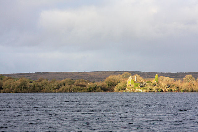
Situated in the NW corner of a bawn (CL017-057003-) and immediately to the N of a 16th/17th-century house (CL017-057002-), on a rocky bluff jutting S into Inchiquin Lough. Drawn as an L-shaped structure and labelled ‘Inchiquin Castle (in Ruins)’ on the OS 25-inch plan (1897) and Cassini edition (1920) of the OS 6-inch map. According to Ua Cróinín and Breen (1997), this tower house was built in 1459 by Teige an Chomhaid Ó Briain, King of Thomond and became the home of the barons of Inchiquin, an important branch of the O’Brien family. The castle was briefly besieged by Conor O’Brien in 1559, during in-fighting within the O’Brien clan (ibid.). In 1599 the castle was attacked and pillaged by Maguire, one of Red Hugh O’Donnell’s soldiers (ibid.). Writing in c. 1600, the satirical poet Aenghus O’Daly lambasted Inchiquin Castle for the very poor hospitality he received there (ibid.). In 1646 a Cromwellian garrison was stationed in the castle but in 1666 Murrough na dToitean Ó Briain, 1st Earl of Inchiquin, was granted the castle, manor and lands by the restored English king, Charles II (ibid.). In about 1700 the castle was the residence of Colonel John O’Brien, who later moved to Killone, near Ennis and died without children in 1709. At some point after he moved away, one Thomas MacGorman of Cahermurphy in west Clare moved to Inchiquin Castle (MacGorman’s second wife, Joan, was related to John O’Brien). While two subsequent generations of MacGormans lived at Inchiquin, the castle remained in O’Brien ownership. In 1702 Sir Donough of Leamaneh and Dromoland conferred the manor of Inchiquin on his second son Henry (ibid.). By 1753 the castle was in the hands of William O’Brien, 4th Earl of Inchiquin. It is unknown when Inchiquin Castle fell into disuse but the tower house was described as ‘nearly levelled’ in an undated document quoted in the OS Letters of 1839 (Comber 1997, 16). Westropp (1899-1901, 359) recounted a tale of the destruction of the ruined tower house by ‘mischievous pleasure seekers’ and Macnamara (1901, 343) dated its destruction to c. 1850.
The main upstanding part of otherwise rubble-filled tower house is its NE corner (H c. 11m), comprising ivy-covered sections of its E (L 4.95m) and N (L 5m; Wth 2m) walls with slight base-batters, and traces of the W wall’s outer face within the rubble. The surviving portion of the E wall (L 4.95m) may retain one side of the tower house’s main entrance doorway at its S end, suggested by a rebate (D 0.26m) on the outer wall-face. Macnamara (1901, 343) described the doorway as ‘gothic’ and Ua Cróinín and Breen (1997) noted a ‘large door-arch stone’ within the rubble nearby. The NE angle contains five or six intact steps of a circular stairwell (ibid.), with a rectangular light (Wth 0.08m; H 1.05m) on the ground floor. On the inner face of the N wall is a single corbel, just above the rubble which fills the interior. Just above the corbel the wall-face is recessed, with a straight edge marking a 1st-floor doorway accessed from the stairs and supported on the recess and corbel. This suggests that there was no vault in the ground-floor ceiling of the tower house, which appears to have had at least three floors. The tower house is built on a rock outcrop plinth immediately to the N of which the rock appears to have been quarried away, perhaps to provide material for the castle and also adding to its defensible position by creating a 3m-high quarry-face on this side. Outside the E wall of the tower house the plinth edge (H c. 2m) is also clearly visible, turning S and merging into the general ground level of the bawn (CL017-057003-). There is a 16th/17th-century house (CL017-057002-) immediately to the S of the tower house, also within the bawn. The tower house was likely in ruins when this later house was built because its N wall would have overlain the presumed line of the S wall of the tower house.
Compiled by: Gearóid Conroy and Conn Herriott
Date of upload: 13-10-2025
The monument record does not grant public access. Check the route and ask the landowner before entering private land.