Add your own picture and explain the route, parking, gates, paths or landmarks that help people find it.
Earn 5 points after the picture is checked and accepted.
Add your photo and local directionsShare what you foundWhat is recorded here
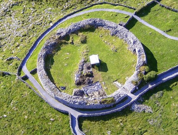
On a shelf at the base of S-facing slope, overlooking a ravine (D c. 10m) immediately S–NW. In rough pasture within a multiperiod field system (CL009-255----). Hachured and labelled ‘Caherlisnanroum’ on the 1842 and 1920 eds. of the OS 6-inch map. Labelled ‘Cathair Lios na nDrom’ on Robinson’s map (1977). This subcircular cashel (27m E–W; 25.6m N–S) is defined by a double-faced wall (Wth 2.7–3m; int. H c. 0.6m; ext. H 0.6–1.4m), the outer face of which is visible all around. Westropp (1917, 73) described it as ‘of poor, but large, masonry for most of its circuit’, probably of the 12th to 14th centuries. Rubble and earth are banked against the wall (total Wth 5.6–8.5m). This spread appears to have been heavily disturbed. No entrance is visible, but Westropp (ibid.) recorded one (Wth 0.86m) at E, ‘very well built of naturally smooth, square blocks’ (L c. 0.8m; Wth c. 0.45m; H c. 0.3m) and ‘long, lintel-like slabs’ which had been present in 1895 but were removed before 1917. In NNW interior there is a distinct quarry (L 3m; Wth 3m; D 0.5m) in the material banked against the cashel wall. Westropp recorded two circular huts (wall Wth 1.8m) abutting the wall’s inner face, one at N and the other at S (see attached image). These were not visible on inspection in 1998.
Field boundaries abut the cashel exterior at NE and SE. Westropp (ibid., 74) observed a ‘natural parallel-sided hollow’ running down the centre of the plot enclosed by these field boundaries, which he interpreted as an annexe to the cashel. An enclosure (CL009-030006-) lies c. 30m to the NNE. Another cashel (CL009-030004-) lies c. 104m to the N.
The following image has been uploaded:
CL009-030005-_01.jpg Sketch plan (Westropp 1917, 74)
Compiled by: Mary Tunney and Conn Herriott
Date of upload: 4 January 2022
The monument record does not grant public access. Check the route and ask the landowner before entering private land.