Add your own picture and explain the route, parking, gates, paths or landmarks that help people find it.
Earn 5 points after the picture is checked and accepted.
Add your photo and local directionsShare what you foundWhat is recorded here
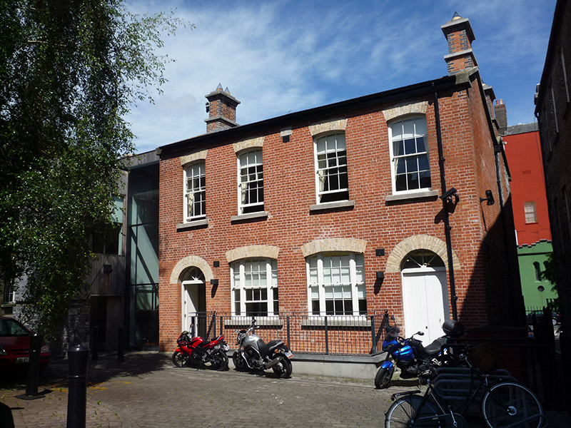
Pair of two-pile semi-detached houses over basements, dated 1872. Now in use as office building, extended to west c. 2010. Pitched slate roofs, with blue/black clay angle ridge tiles, polychrome stepped chimneystacks to east and west gables, each with projecting stone strings and caps, granite verge stones and kneelers to gables, moulded gutters, and round-profile cast-metal downpipes. Flemish bond red brickwork walling to front pile, with cut limestone date-stone under eaves, and uncoursed rubble limestone walling having ashlar quoins to rear pile. Segmental-headed window openings to front pile, with granite sills, tripartite windows to ground floor with six-over-six pane lights flanked by two-over-two pane lights, and with six-over-six pane windows to first floor. Square-headed window openings to north pile, with granite sills, red brick jambs, rubbed yellow brick voussoirs and six-over-six pane timber sliding sash windows. Round-headed entrance door openings to front elevation, with rubbed yellow brick voussoirs, and vertically divided timber doors with spoked fanlights. Mild steel fence on plain rendered plinth wall, with limestone copings to front and rear basement areas. Extension variously clad with polished ashlar limestone on rubble stone base, with horizontal slit windows to west elevation, vertical timber boarding effecting transition with north elevation, and planar glazing effecting transition with south elevation. Paved surfaces to south and north, with clock tower building to east.
This official record and map point do not grant access. Most recorded buildings are privately owned; view them only from public ground unless the owner allows entry.