Add your own picture and explain the route, parking, gates, paths or landmarks that help people find it.
Earn 5 points after the picture is checked and accepted.
Add your photo and local directionsShare what you foundWhat is recorded here
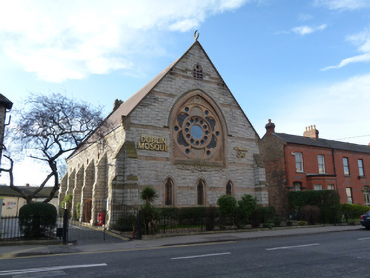
Attached Gothic Revival gable-fronted former Presbyterian church, built 1880-1881, with four-bay nave, now in use as mosque. Pitched slate roof with cut sandstone barge copings and recent crescent finial to front (north) gable. Snecked rock-faced granite walls with ashlar sandstone string courses to north gable, and stepped buttresses to east and west elevations. Pointed arch window openings with twin light lancet windows, sandstone surrounds and sloping sandstone sills to nave. Rose window set in pointed arch ashlar sandstone surround, having hood moulding, sloping sill and stained glass window to north elevation. Trefoil-headed window openings to north gable, having chamfered limestone surrounds and sills, and leaded stained glass windows. Pointed arch door opening to east elevation flanked by carved limestone and sandstone colonnettes approached by granite steps, with timber battened door having inset sandstone tympanum. Pointed arch door opening with sandstone quoins, granite steps and timber battened door to west elevation. Interior having timber Minbar and Mihrab to east elevation, timber gallery to west. Former chancel arch to south, with render hood moulding. Stained glass windows. Exposed roof timbers. Set in own grounds, with cast-iron railings on granite plinth to north and east. Five-bay single-storey former school building to south elevation, built c.1891, recently substantially rebuilt.
This official record and map point do not grant access. Most recorded buildings are privately owned; view them only from public ground unless the owner allows entry.