Add your own picture and explain the route, parking, gates, paths or landmarks that help people find it.
Earn 5 points after the picture is checked and accepted.
Add your photo and local directionsShare what you foundWhat is recorded here
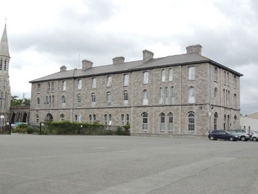
Detached ten-bay three-storey house of retreat, built 1858-62, with breakfronts of three bays to each end of front (south-east) elevation and to north-east elevation, each in turn having central breakfront. Single-storey extension to north end of rear (north-west) elevation, and full-height six-bay three-storey extension to south end of rear elevation, built 1950. Now also in use as parish office, archive and retirement home. Hipped artificial slate roof with stepped limestone chimneystacks and cast-iron rainwater goods. Ashlar limestone walls to front, north-east and south-west elevations, having carved plinth course. Brown brick walls laid in English garden wall bond to rear (north-west) elevation. Roughcast rendered walls to rear and north-east elevations of 1950 extension. Round-headed recessed window openings with chamfered surrounds to ground and first floors, and to all floors of breakfronts. Recessed shouldered square-headed window openings set in chamfered round-headed surrounds to centre of first floor front elevation, and set in chamfered elliptical-headed surrounds to second floor. Cut limestone sill course to first floor. Paired window openings to ground floor and second floor breakfronts, windows in threes to first floor breakfronts. Square-headed window openings to rear elevation, round-headed to ground floor, with brick voussoirs and cut granite sills. Replacement uPVC windows throughout. Round-headed door opening to front elevation, having recessed carved limestone surround, engaged Doric pilasters supporting entablature, stained glass overlight and sidelights, and double-leaf timber-panelled door. Round-headed door openings to north-east and south-west elevations with replacement uPVC overlights and stone steps. Linked to Church of Mary Immaculate to south-west by screen wall, built 1946. Wrought-iron railings to north-east elevation. Limestone boundary walls and gate piers with cast-iron railings and gates to south-east. Oblate cemetery to north-west and replica grotto of Lourdes to west (1930). Rubble stone triple arched folly , built c.1910, to west, comprising ogee-headed central arch flanked by pointed arch openings, with crennellated pinnacles. Scoil Mhuire Gan Smál national school (1936) to north-east.
This official record and map point do not grant access. Most recorded buildings are privately owned; view them only from public ground unless the owner allows entry.