Add your own picture and explain the route, parking, gates, paths or landmarks that help people find it.
Earn 5 points after the picture is checked and accepted.
Add your photo and local directionsShare what you foundWhat is recorded here
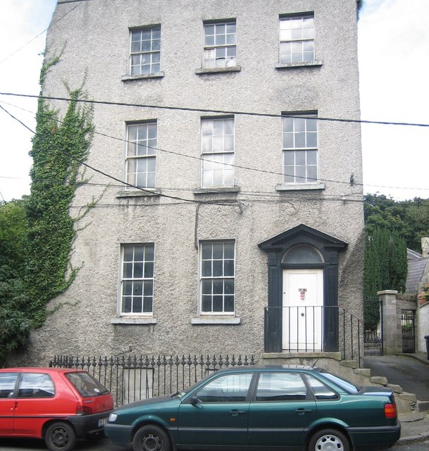
Detached three-bay three-storey early Georgian house over raised basement, built c.1740, with chamfered corner to southeast. Front wall extends to west to form semi-buttress. Roof concealed by parapet to main south elevation, M-profile hipped roof concealed by parapet to south elevation. Valley screened by contiguous slate-capped truncated chimneystack to west gable, natural slate with angled ridge and hip tiles. Generally cast-iron rainwater goods, with replacement uPVC replacement downpipe to south. Walling is cement-based roughcast throughout over smooth cement rendered base course to east side and parapet has dressed granite coping. Windows are square-headed horned timber sliding sashes in plain reveals with painted masonry sills, generally six-over-six pane, with occasional plain sashes and windows diminish in height to front elevation. Irregular fenestration to rear. Boarded basement windows have timber sills. Replacement timber door contained in doorcase comprising panelled timber pilasters supporting dentillated open-bed pedimented entablature embracing plain round fanlight. Door addressed by seven granite steps running up wall to platform bounded by replacement metal railings and containing cast-iron boot-scraper. Railed area to basement accessed by four rubble masonry steps, original cobbles interspersed by clay tiles. Bounded by cast-iron spear-headed railings on granite plinth. House set on roadside, with lanes to either side leading to Church of Saint Lawrence to rear. Original stone setts survive, those to north side almost concealed beneath later tarmac resurfacing. Enclosed yard to side and rear bounded by high roughcast wall with rubble stone soldier coping. Boundary wall to rear shared by historic churchyard.
This official record and map point do not grant access. Most recorded buildings are privately owned; view them only from public ground unless the owner allows entry.