Add your own picture and explain the route, parking, gates, paths or landmarks that help people find it.
Earn 5 points after the picture is checked and accepted.
Add your photo and local directionsShare what you foundWhat is recorded here
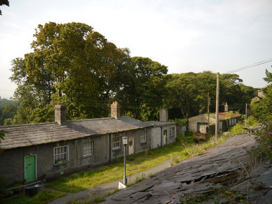
Parallel terraced rows of single-storey three-bay former staff accommodation buildings, built c.1810, now largely derelict and overgrown. Some to south row remain in residential use. Slate roofs, mono-pitched to north, pitched with hipped ends to south. Some derelict ranges to northwest overgrown but have gabled half-dormered attic and large segmental-headed archways. Generally yellow brick chimneystacks with replacement sections in red brick. Cast-iron and replacement rainwater goods on wall-driven brackets. Roughcast-rendered walling over cement plinth. Square-headed window openings, with rendered reveals and granite sills. Openings boarded to north range, sliding timber sashes to south range, three-over-three pane to south elevation behind wire grilles and four-over-four pane to north. Square-headed door openings with smooth rendered reveals, generally boarded to north, modern replacement doors to south range, with timber sheeted door to one. Flat-roofed parapeted two-bay building abuts to west of south range, with tall rendered chimneystack and metal windows. Barrel-shaped corrugated-iron roof to south central block, built c.1900, having red brick walling laid to English garden wall bond, rubble limestone west gable and yellow brick chimneystack, over-sized square-headed window openings with brick voussoirs and granite sills, windows removed/boarded, roller shutter to vehicular doorway. Abutted to west by ruinous mono-pitched red brick stores, roof structure largely collapsed, with segmental-headed openings with some remnants of timber sheeted double-leaf doors. Set into steep hillside to south of Saint Mary’s Hospital, surmounted by roughcast-rendered boundary wall with granite coping and modern steel railings. Rear of terraces forms boundary walls to south and east, with central street accessed to east via segmental-headed arch with calp limestone voussoirs and buttressed architraves. Remaining range to west heavily overgrown and collapsed, mature planting to west end of northern range. Former non-commissioned officers' quarters to west.
This official record and map point do not grant access. Most recorded buildings are privately owned; view them only from public ground unless the owner allows entry.