Add your own picture and explain the route, parking, gates, paths or landmarks that help people find it.
Earn 5 points after the picture is checked and accepted.
Add your photo and local directionsShare what you foundWhat is recorded here
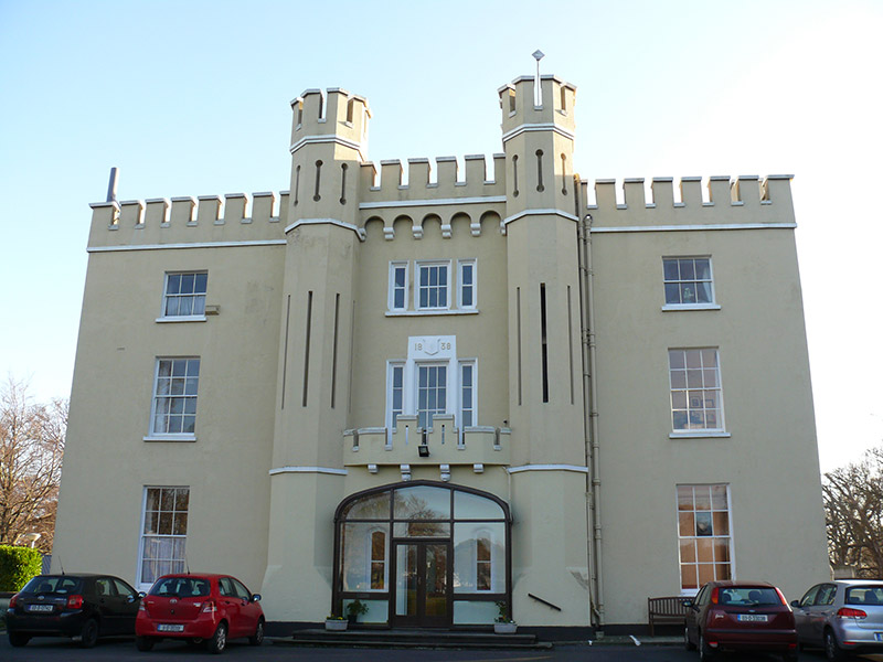
Detached three-bay three-storey house over basement, dated 1838, incorporating mid-eighteenth-century fabric, having projecting central breakfront flanked by octagonal-plan towers, full-height bow bay flanked by octagonal towers to rear, and with central projecting chimneybreast to south-west elevation with bull-nosed corners. Recent glazed porch to front (north-west) elevation, recent single-storey extension to north-east. Now in use as retreat centre. Triple-span hipped natural slate roof, surrounded by crenellated rendered parapet over render stringcourse, machicolated parapets to bow bay and breakfront to front, machicolation to north-east elevation, and cast-iron rainwater goods. Smooth rendered walls with render stringcourses, plinth course, and having stepped batter to base of towers to rear. Square-headed window openings with painted masonry sills, one-over-one pane, three-over-three pane and six-over-six pane timber sliding sash windows, tripartite arrangement of timber casement windows to first and second floors of breakfront, date plaque to first floor of breakfront, and moulded render paviors over windows to second floor of bow bay to rear. Square- and round-headed lancet window openings to north-east elevation with timber windows. Square-headed and cruciform arrow loops to towers and chimneybreast. Pointed arch door opening to front with chamfered render surround, half-glazed timber panelled door and plain overlight, flanked by pointed arch sidelights, chamfered render surrounds and one-over-one pane timber sliding sash windows. Recent glazed timber framed porch to front. Crenellated render balustrade to balcony over entrance, with moulded render gargoyle drains and corbels beneath balcony. Lawned areas to front and rear. Set in own grounds.
This official record and map point do not grant access. Most recorded buildings are privately owned; view them only from public ground unless the owner allows entry.