Add your own picture and explain the route, parking, gates, paths or landmarks that help people find it.
Earn 5 points after the picture is checked and accepted.
Add your photo and local directionsShare what you foundWhat is recorded here
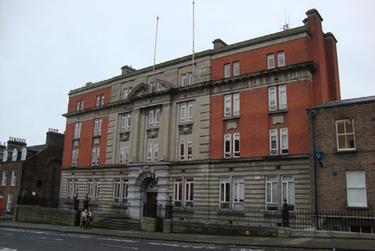
End of terrace seven-bay four-storey police station over exposed basement, built 1912-13, now in use as Garda Síochána station. Flat roof hidden behind parapet having four long chimneystacks distributed on roof, paired chimneystack abutting west elevation. Masonry coping to parapet. English bond red brick walls to two bays at each end of facade at level of upper floors. Portland stone to central three bays, flanked by quoins at junction with brick, and moulded Portland stone plinth course over channelled composition stone to ground floor. Portland stone entablature forming second floor lintel, surmounted by machicolated deep cornice having broken segmental pediment to third floor supported by giant engaged pilasters spanning first and second floors. Paired square-headed window openings to each bay, gauged brickwork to those to flanking bays, and stone quoins to those to central masonry bays. Large ornate cartouche under second floor windows to central bays, plain Portland stone aprons under second floor windows to flanking bays, replacement uPVC windows throughout. Limestone door surround to ground floor, with quoined voussoirs surrounding ornate spoked fanlight over double-leaf timber panelled door, with bronze Garda emblem to central keystone. Four granite steps to concrete entrance platform, flanked on either side by early twentieth-century cast-iron railing and decorative corner posts on masonry plinth wall having moulded granite coping. Matching gates to east and west of steps allowing access to basement. Plain red brick laid in English bond to east and west elevations. Yellow brick to south elevation, with five-storey return, accessed via Charles Lane to west. Three coal-hole covers to poured concrete pavement by Tonge and Taggart, and with granite kerbstones to setts at road edge.
This official record and map point do not grant access. Most recorded buildings are privately owned; view them only from public ground unless the owner allows entry.