Add your own picture and explain the route, parking, gates, paths or landmarks that help people find it.
Earn 5 points after the picture is checked and accepted.
Add your photo and local directionsShare what you foundWhat is recorded here
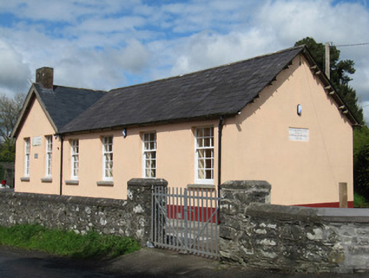
Detached four-bay single-storey former national school, dated 1861, having flat-roofed porch to north gable, with gabled four-bay single-storey extension of c.1980 at right angles to north end of original block, and flat-roofed single-storey extensions to re-entrant corner to rear (west) elevation. Now in use as community centre. Pitched slate roofs, timber corbelled eaves to earlier block, red brick chimneystacks to later block. Smooth rendered walls with limestone plaques inscribed: "DERRYCOONEY [sic] NATIONAL SCHOOL ERECTED BY/RICHARD ALLEN MINNITT ESQ. J.P. A.D. 1861" and "Scoil Doire Ó gCuanaigh Scoil Náisiúnta". Square-headed window openings with cut limestone sills, having six-over-nine pane timber sliding sash windows to front elevations of both blocks, and timber casement windows to rear elevation of earlier block. Square-headed door openings, with recent timber door and over-light to porch, and with timber battened door to rear elevation of earlier building. Recent timber windows and doors to flat-roofed extensions. Remains of toilet block to north of site. Double-leaf wrought-iron gate with rubble stone piers to south of site, recent metal pedestrian gate with rendered piers to north-east of site, rubble stone and stone-clad boundary walls with render capping. Set in own grounds at junction of four roads.
This official record and map point do not grant access. Most recorded buildings are privately owned; view them only from public ground unless the owner allows entry.