Add your own picture and explain the route, parking, gates, paths or landmarks that help people find it.
Earn 5 points after the picture is checked and accepted.
Add your photo and local directionsShare what you foundWhat is recorded here
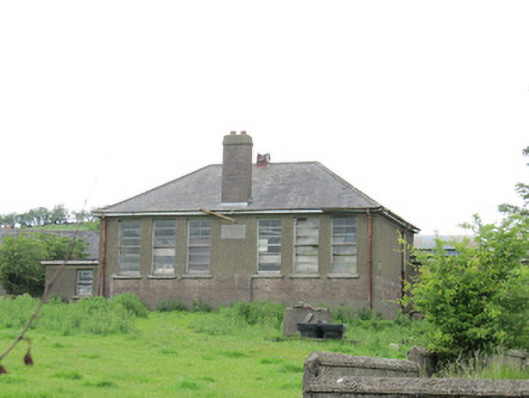
Detached six-bay single-storey national school, dated 1941, with lower flat-roofed two-bay cloakroom block to either side, set back from front (south-east) elevation, and wrapping around rear elevation. Now disused and derelict. Hipped slate roof with red brick chimneystack and with timber bargeboards to flat-roofed section. Metal vent to ridge. Some cast-iron rainwater goods. Roughcast rendered walls, having red brick walls forming band at sill level. Inscribed limestone date plaque to front elevation reading 'Scoil Ultán Naomhtha/Lagán/Scoil Náisiúnta 1939', and further plaques to cloakroom blocks reading 'Buachaillí/Boys' and 'Cailíní/Girls'. Square-headed window openings with tooled stone sills throughout, having horizontal pane timber sliding sash windows, three-over-three pane to front of main block, one-over-one pane to rear elevation of cloakrooms, and two-over-two panes elsewhere. Timber pivoting windows at clerestory level of main block to rear elevation. Square-headed door openings, having half-glazed timber panelled doors and plain masonry surrounds. Remains of rendered boundary wall dividing yard to rear. Concrete play shelter to north-west side of yard, having flat roof, some cast-iron rainwater goods, concrete walls on three sides, and round-plan pier to open side. Set back from road, with site entrance to south-east, having remains of steel double-leaf gate, and recent farm gate. Rendered square-plan piers and rendered boundary walls.
This official record and map point do not grant access. Most recorded buildings are privately owned; view them only from public ground unless the owner allows entry.