Add your own picture and explain the route, parking, gates, paths or landmarks that help people find it.
Earn 5 points after the picture is checked and accepted.
Add your photo and local directionsShare what you foundWhat is recorded here
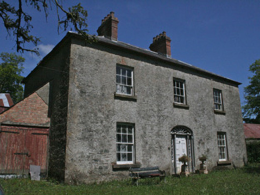
Detached three-bay two-storey house, built c.1780, with three-bay single-storey return to middle of rear, and lean-to single-storey structure to west gable. Hipped slate roof, with paired red brick chimneystacks with decorative cast-iron pots, tall red brick stack to return, and cast-iron rainwater goods. Rendered coursed rubble stone walls, with cut-stone quoins. Square-headed diminishing window openings, with original six-over-three pane timber sliding sash windows to first floor, and six-over-six pane timber sliding sash windows to ground floor, with rendered reveals, stone sills and evidence of gauged-brick window surrounds where render has come away. Square-headed window opening to return with two-over-two pane timber sliding sash windows. Elliptical-headed main door opening, with original doorcase, to centre of south elevation, having cobweb fanlight and geometrical-glazed sidelights, set in stone door surround of engaged fluted round-plan columns on engaged square-plan plinth, with plain moulded entablature. Original raised-and-fielded panelled door of eight panels, and cast-iron doorbell to wall. Range of single and two-storey stable and farm buildings forming courtyard to rear, with pitched slated roofs, coursed rubble limestone walls, segmental-headed openings with brick surrounds to timber battened doors doors and timber-framed windows. Double-leaf wrought-iron vehicular gate to east of house with square-plan piers, decorative wrought-iron pedestrian gate to south of house flanked by cut-stone square-plan piers. Main approach from south-west with wrought-iron gates on square-plan piers, with curved wall to either side. Located north of Ballybay to Newbliss road to north of Drumkeen Presbyterian Church and Dundalk to Enniskillen Branch of Ulster Railway.
This official record and map point do not grant access. Most recorded buildings are privately owned; view them only from public ground unless the owner allows entry.