Add your own picture and explain the route, parking, gates, paths or landmarks that help people find it.
Earn 5 points after the picture is checked and accepted.
Add your photo and local directionsShare what you foundWhat is recorded here
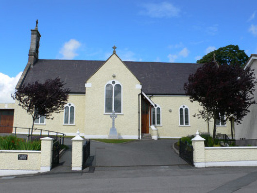
Free-standing gable-fronted Roman Catholic church with Byzantine-Romanesque detailing, built 1810, rebuilt 1924-5 after fire, to designs by Rudolf Butler. T-plan with six-bay nave, easternmost bay slightly recessed, and with single-bay gabled transept having lower ridge. Flat-roofed aisle abutting north elevation, with chapel and boiler shed outshots, flat-roofed porch to west gable, and modern catslide porch abutting east elevation of transept. Pitched slate roof with roll-top blue/black angled ridge tiles, stone Celtic Cross finials and verges on painted eaves corbel blocks, and half-round metal gutters. Cut sandstone bell-cote with Celtic Cross finial and offset, pointed-arch aperture containing single bronze bell with lettering '[Sheridan?]…Dublin 1873'. Rendered chimneystack to east end party wall of nave/chancel and north aisle/sacristy. Painted roughcast walling over napped plinth; strip buttresses to ends of east gable. Round-headed stained-glass casement lancets throughout, single to north aisle east and west elevations, bipartite to porch, tripartite to nave gables, bipartite to nave in round-headed napped surround with oculus above double round-headed lights, with render sills. Square-headed replacement timber battened doors to porches. Front porch has stone stoups and Minton-like herringbone tiled floors with polychrome lozenge-patterned margins. Nave has gallery to west end of nave, round-arch arcade with similar arch to transept. Aisle ends in side chapel with door accessing sacristy to east end of chancel and behind side chapel. Exposed timber roof structure supported on painted stone corbels, with timber sheeted roof over rafters and purlins. Set back from road, with steel gates and rubble and roughcast plinth wall with modern inset plaque inscribed 'Saint Mary’s Church Erected 1810 AD.' Situated on sloping site rising to north-east, with terraced lawn and bitmac pathways, with stone Celtic Cross to priest’s grave to front of transept gable, terraced ditch surrounding west porch and north aisle, rendered modern two-storey house to south-east of church at roadside, modern school-house across road to south, substantial graveyard with rendered stepped wall enclosing graveyard with mostly twentieth-century gravestones and 'Jubilee' mission crucifix, dated 2000, to east end of graveyard.
This official record and map point do not grant access. Most recorded buildings are privately owned; view them only from public ground unless the owner allows entry.