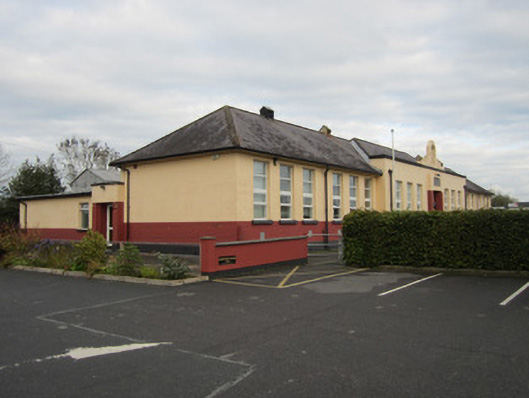
Add your own picture and explain the route, parking, gates, paths or landmarks that help people find it.
Earn 5 points after the picture is checked and accepted.
Add your photo and local directionsShare what you foundWhat is recorded here
Detached thirteen-bay single-storey national school, dated 1937, having slightly advanced seven-bay entrance block with bellcote over, flanked by six-bay wings. Two-bay two-storey return to middle of rear elevation, flanked by multiple-bay single-storey blocks. Hipped slate roof to main block with concrete ridge and louvred steel ventilators, and brick chimneystack with concrete cap to return. Cast-iron rooflights to return. Cast-iron ogee-profile rainwater goods on overhanging sprocketed eaves having smooth rendered soffits with parapet gutter to entrance block drained by cast-iron hopper heads and round downpipes. Parapet to front has plain capping with stepped element to centre having empty bellcote to summit. Painted smooth rendered walls to front façade and side elevations with painted engineering bricks below window sill level and smooth rendered projecting base. Unpainted rectangular stone plaque over entrance reads, in Gaelic script, 'Scoil na mBráthar gCríostamhail fá chomairce na Maighdine Muire/Scoil Náisiúnta/1937'. Rear elevation of main structure roughcast rendered with painted smooth rendered base. Square-headed window openings throughout with replacement uPVC frames, and concrete sills. Square-headed replacement double-leaf partially glazed timber door to entrance, with overlight and having stepped brick pilasters to either side holding projecting square block carrying plaque over doorway. Similar but smaller entrance to west elevation of flat-roof block to rear, with replacement uPVC door and smooth rendered parapet supported by stepped brick pilasters. Building has small lawned area to front, and large hard-surfaced playground and car parking to rear and west respectively. Temporary classroom accommodation located to east side of rear yard.
This official record and map point do not grant access. Most recorded buildings are privately owned; view them only from public ground unless the owner allows entry.