Add your own picture and explain the route, parking, gates, paths or landmarks that help people find it.
Earn 5 points after the picture is checked and accepted.
Add your photo and local directionsShare what you foundWhat is recorded here
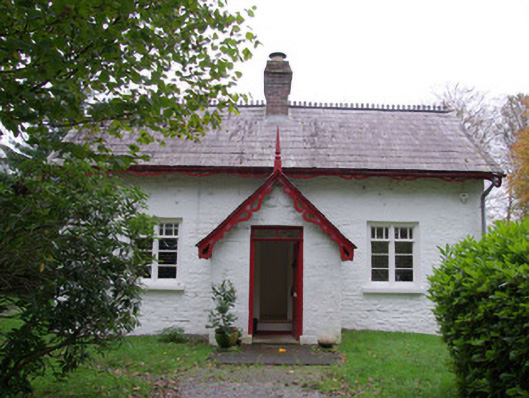
Detached three-bay single-storey with attic level former gate lodge, built c. 1860, having central projecting gable-fronted single-bay entrance porch to the main elevation (north-east), original cat-slide outshot incorporated into modern single-storey pitched extension to southwest. Originally associated with Lough Eske Castle (see 40909401). Now in use as a private house with modern single-storey extension to the rear (south-west). Pitched natural slate roof with fleur-de-lis crested clay ridge tiles, central red brick chimney stack having stepped brick detailing to head and with terracotta pots, and having decorative pierced timber bargeboards to the front (north-east) and side elevations (south-east and north-west). Pitched natural slate roof to porch having crested ridge tiles, and with decorative pierced timber bargeboards with timber finial to gable apex. Whitewashed random rubble stone walls with flush dressed block-and-start quoins to the corners; mainly ashlar construction to front face of porch. Square-headed window openings with rendered reveals, stone sills, and with timber casement windows having multi-paned overlights. Two-over-four pane timber sliding sash windows to attic level at gable ends; two-over-two pane timber sliding sash windows to side elevations of porch. Central square-headed door opening to front face of porch having dressed stone plinth blocks to base, stone step/threshold, replacement timber sheeted door and with overlight. Set back from road in extensive mature grounds to the north-east of Donegal Town and to the south/south-west of Lough Eske Castle. Located adjacent to rural crossroad junction. Modern gateway to the north-east; former south/south-west entrance to Lough Eske Castle demesne located across road to the north-east.
This official record and map point do not grant access. Most recorded buildings are privately owned; view them only from public ground unless the owner allows entry.