Add your own picture and explain the route, parking, gates, paths or landmarks that help people find it.
Earn 5 points after the picture is checked and accepted.
Add your photo and local directionsShare what you foundWhat is recorded here
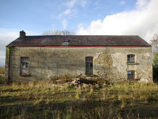
Detached three-bay two-storey double-pile former co-operative creamery with attic level, built c. 1903 and rebuilt or partially rebuilt c. 1921/2. Loading platform the south-west side elevation. Now out of use (since early 1970s). Pitched natural slate roofs with smooth rendered chimneystacks to southwest gable ends, and with cast-iron rainwater goods. Iron skylights to roof, four to north-west facing pitches (two to each north-west pitch). Roughcast rendered finish over roughly squared rubble stone construction (exposed in places) and with roughly dressed flush quoins. Segmental- and square-headed window openings with fixed timber-casement windows and timber sliding sash windows, and with some dressed sandstone sills. Number of window openings now boarded. Square-headed vents to attic level at gable ends having timber louvered vents to openings. Square-headed door openings to gable ends with timber battened doors. Square-headed carriage-arch to south-west gable with timber battened double doors, accessed via loading ramp. Multi-pane overlight to one door opening to the southwest gable end. Flight of steps to northeast gable having iron swinging crane mechanism. Outline of former single-storey leant-to annex to north-west elevation, now demolished (c. 2006). Interior contains working intact buttery and mechanisms of creamery, c. 1930, including a large timber and metal churn. Set within own grounds with ruinous single-storey outbuilding to rear (east), having roughly squared rubble stone walls (roughcast rendered to side elevations), pitched roof (now collapsed), and square-headed door opening to northwest gable end. Low rubble stone boundary wall to frontage to west. Gateway to the south-west end of boundary wall comprising a pair of rubble stone gate piers (on square-plan) having a wrought-iron flat bar gate. Millrace associated with former corn mill (40909201) located to west runs across the north side of the site. Located to the south of associated former creamery manager’s house (40909206), and to the west of Inver.
This official record and map point do not grant access. Most recorded buildings are privately owned; view them only from public ground unless the owner allows entry.