Add your own picture and explain the route, parking, gates, paths or landmarks that help people find it.
Earn 5 points after the picture is checked and accepted.
Add your photo and local directionsShare what you foundWhat is recorded here
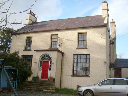
Detached three-bay two-story over basement former Church of Ireland rectory with attic level, built or rebuilt/altered c. 1810 and probably containing earlier fabric to rear (west). Single-bay flat-roofed entrance porch to the centre of the front elevation (east). Later single-storey blocks attached to the north and south elevations. Now in use as a private house. Pitched natural slate roofs, having raised ashlar limestone verges/copings to gable ends (north and south), projecting eaves course to main block (east), some remaining sections of profiled cast-iron rainwater goods, and having rendered chimneystacks to gable ends having cut stone coping, cut stone stringcourse, and terracotta pots on octagonal plan. Roughcast rendered walls. Square-headed window openings with stone sills and with six-over-six pane timber sliding sash windows at first floor level, tripartite/Wyatt-style windows at ground floor level having central nine-over-six pane timber sliding sash windows flanked by sidelights. Round-headed door opening to front face of porch (east) having timber panelled door with decorative door furniture, wide spoked fanlight over, and with multi-paned sidelights. Flight of cut stone steps to entrance. Set back from road in extensive mature landscaped and wooded grounds adjacent to the Eany Water and a short distance to the north of Inver Bay. Single-storey outbuilding/coach house to the north-west of house having half-hipped natural slate roof, rubble stone walls, cast-iron rainwater goods, and square-headed doorways and carriage-arches. Single-storey outbuilding/stables to rear (west) having pitched corrugated metal roof, rendered walls, and square-headed doorways with battened timber half doors. Yards to rear (west) and to front (east) of house. Remains of former walled gardens to the south-west, now out of use with modern house to walled garden to the north, having rubble stone boundary walls. Square-headed entrances to west side of walled garden. Main gateway to site to the north of house, adjacent to the Eany Water, comprising a pair of stone gate piers (on square-plan) having rock-faced capstones over having dressed margins, and with wrought- and cast-iron gate having fleur-de-lis finials. Pedestrian gateway adjacent to the west having stone gate pier (on square-plan) with rock-faced capstone over with dressed margin, and having wrought- and cast-iron gate. Single-storey gate lodge (see 409092015) adjacent to main gateway. Long approach avenue to house from the main entrance to the north. Secondary entrance to the west. Rubble stone and rendered boundary walls and walls to site.
This official record and map point do not grant access. Most recorded buildings are privately owned; view them only from public ground unless the owner allows entry.