Add your own picture and explain the route, parking, gates, paths or landmarks that help people find it.
Earn 5 points after the picture is checked and accepted.
Add your photo and local directionsShare what you foundWhat is recorded here
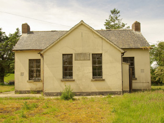
Detached four-bay single-storey former national school on T-shaped plan, dated 1934, having advanced gable-fronted two-bay breakfront\projection to the centre of the front elevation (east). Later projecting single-bay single-storey flat-roofed entrance porch to the north side of front projection. Now out of use and derelict. Pitched natural slate roofs having clay ridge tiles, red brick chimneystacks to the gable ends (north and south) with chimneybreasts projecting from gable walls, central metal roof vent, and having cast-iron rainwater goods. . Smooth cement rendered walls with inscribed cut stone date and name plaque to the front projection dated 1934. Square-headed window openings to main body of building having six-over-six pane timber sliding sash windows and stone sills, square-headed window openings to front face of breakfront (east) having four-over-four pane timber sliding sash windows and stone sills; squared-headed window openings to the gable ends having six-over-nine pane timber sliding sash windows and stone sills. Square-headed doorways to the side elevations of breakfront (south, and to porch to north) having battened timber doors. Plastered walls and timber boarded ceilings to classrooms. Set back from road in own grounds to the south-east of Castlefinn with overgrown playgrounds to site. Detached single-storey open playshed to the south-west of site. Single-storey former toilet block to the south of site, now demolished. Rubble stone and rendered boundary walls to road-frontage to the east. Gateway to the east having a pair of rendered gate piers (on square-plan), and with a pair of wrought-iron flat bar gates. New Alt school located to south-west, dated 1960.
This official record and map point do not grant access. Most recorded buildings are privately owned; view them only from public ground unless the owner allows entry.