Add your own picture and explain the route, parking, gates, paths or landmarks that help people find it.
Earn 5 points after the picture is checked and accepted.
Add your photo and local directionsShare what you foundWhat is recorded here
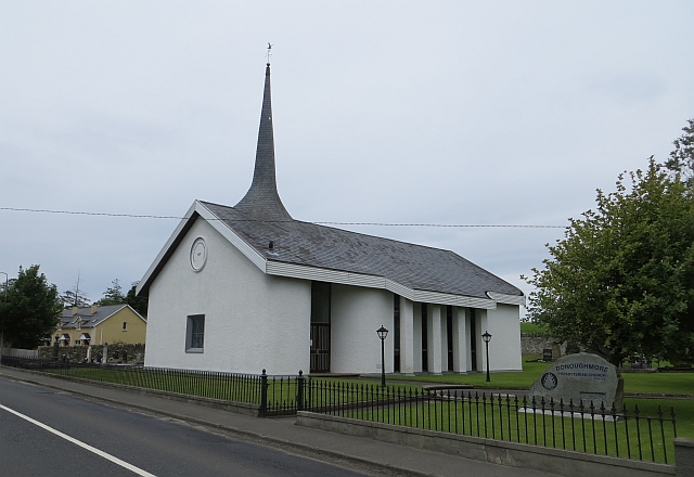
Detached multiple-bay double-height Presbyterian church\meeting house on irregular rectangular plan, built 1977, having tapering slate-clad spire (on diamond or lozenge-shaped plan) to south end with metal weather vane over, shallow projection to the east elevation and projecting porch to the north-west corner contained under same roofline. Shallow pitched natural slate roof having curved corners to the north end. Wide timber bargeboards to eaves. Roughcast rendered walls, staggered to east elevation incorporating full-height windows\lights, over concave plinth course, and with curved corners. Circular cast-cement date plaque to the south gable end reading ‘Donaghmore Presbyterian Church 1977’. Square headed window openings with recessed full-height lights to east elevation, five recessed square window openings to the west elevation and single light to the south elevation having pronounced chamfered reveals and leaded coloured glass panels. Square-headed door opening to the south-east corner of east elevation having glazed timber double doors with full-height overlight above, and with raised stone threshold on circular-plan. Square-headed doorway to porch projection to the north end of the west elevation having glazed timber door with full-height overlight. Sunday school upstairs to interior; tapestry of a burning bush behind pulpit. Set back from road in own grounds to the east of Liscooly crossroads, and to the west of Castlefinn. Low rendered boundary wall to road-frontage to the south having cast-iron railings over; rubble stone boundary wall to the west of site; carpark and modern manse to the east of site. Collection of re-erected cut stone and marble gravemarkers to the west of the church (of nineteenth and twentieth-century date), some with railed enclosures.
This official record and map point do not grant access. Most recorded buildings are privately owned; view them only from public ground unless the owner allows entry.