Add your own picture and explain the route, parking, gates, paths or landmarks that help people find it.
Earn 5 points after the picture is checked and accepted.
Add your photo and local directionsShare what you foundWhat is recorded here
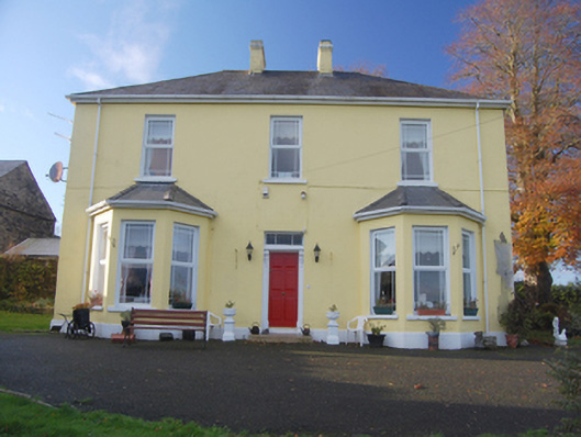
Detached three-bay two-storey house, built c. 1890, having single-storey canted bay windows to either side of central doorway to the main elevation (east), and with single-storey block or earlier house to rear, built c. 1800. Hipped slate roof with projecting eaves course, and a central pair of rendered chimneystacks with moulded smooth rendered cornice course. Hipped slate roofs to canted bays. Smooth rendered ruled-and-lined walls over projecting smooth rendered plinth. Square-headed window openings with painted stone sills, and having replacement windows with margin glazing effect. Central square-headed doorway with replacement timber panelled door, flanking timber pilasters with decorative timber consoles over, moulded timber lintel, and with overlight. Attached block or earlier house to rear, built c. 1800, having pitched corrugated-sheeted roof with rendered chimneystack and some surviving sections of cast-iron rainwater goods, roughcast rendered walls, and square-headed window openings with replacement fittings; extension to the south side of earlier block\house having pitched slate roof, rubble stone walls, and square-headed window openings with replacement fittings. Set back from road in own grounds in the rural countryside to the north-east of Ballindrait. Formal garden to the east. Garden to the east and south-east enclosed by rubble stone boundary wall with rubble stone solider coping over. Gateway to the north comprising a pair of roughcast rendered gate piers (on square-plan) having a pair of wrought-iron flat bar gates. Gateway flanked to either side by curved quadrant sections of roughcast rendered boundary walls. Detached four-bay two-storey outbuilding to the south having external flight of rubble stone steps to the west elevation having access to doorway at first floor level, pitched natural purple slate roof, coursed rubble stone walls with dressed ashlar block-and-start quoins to corners, date stone to south elevation reading ‘John Macbeth A.D. 1860’, square-headed openings with red brick reveals at first floor level. Two-storey outbuilding to the south-west, arranged parallel with dated outbuilding, having pitched natural slate roof, rubble stone walls, and square-headed window and door openings. Modern outbuildings and farm buildings to site.
This official record and map point do not grant access. Most recorded buildings are privately owned; view them only from public ground unless the owner allows entry.