Add your own picture and explain the route, parking, gates, paths or landmarks that help people find it.
Earn 5 points after the picture is checked and accepted.
Add your photo and local directionsShare what you foundWhat is recorded here
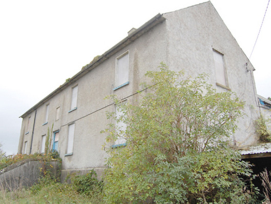
Detached five-bay two-storey over basement former charter school, built c. 1740, having later two-bay single-storey return to the rear at the north-west corner, c. 1895, with single-bay single-storey gable-fronted entrance porch attached to the west gable end. Later in use as day school (from c. 1810) and then as national school from c. 1895. Now out of use (since 2001) and replaced by modern school to the east. Pitched purple natural slate roof to main building having cut stone eaves course, single smooth rendered brick chimneystack with clay pots, and some surviving sections of cast-iron rainwater goods. Pitched natural slate roof to extension to the north-west having exposed rafter ends, timber bargeboards to gable ends, and with remains of cast-iron rainwater goods. Roughcast rendered walls to main building over projecting smooth rendered plinth course, and with carved stone plaque (on rectangular-plan) over entrance door to centre of east elevation reading ‘For the increase of true religion and of industry this school house was built by the Society for Promoting English Protestant Schools. The Right Revd Father in God Nicholas Forstar, Lord Bishop of Raphoe contributing fifty pounds, William Forward Esq. Twenty Pounds, John Lesley of Kincragy Esqr Endowed it two acres of Land, James King The Rector of This Parish D.D. Anno Dom 1740’. Roughcast rendered brick to later addition to the north-west with roughcast rendered walls to porch to the west (render now falling exposing red brick construction). Square-headed window openings to main block having smooth rendered reveals, stone sills, and remains of timber sliding sash windows (windows now blocked). Segmental-headed window openings to later addition having stone sills (windows now blocked). Central square-headed doorway to the east elevation of main block having smooth rendered reveals, timber panelled double doors, and square-headed overlight (now blocked); doorway approached by series of rendered (cut stone?) steps having rendered boundary walls to either side; limestone flags to threshold. Segmental-headed doorway (now blocked) to the north face of porch to the block to the north-west. Set back from road at right-angle to road-alignment. Gateway to the north of site comprising a pair of partially rendered rubble stone gate piers (on square-plan) with wrought-iron flat bar gates. Rubble stone boundary walls to site. Remains of small walled garden (on square-plan) with rubble stone boundary walls to the south-west of site. Set back from road in own grounds in the rural countryside to the south of Manorcunningham.
This official record and map point do not grant access. Most recorded buildings are privately owned; view them only from public ground unless the owner allows entry.