Add your own picture and explain the route, parking, gates, paths or landmarks that help people find it.
Earn 5 points after the picture is checked and accepted.
Add your photo and local directionsShare what you foundWhat is recorded here
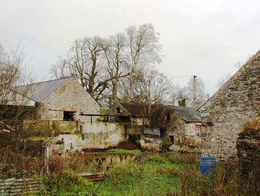
Complex of outbuildings associated with Castlegrove (see 40905409), built c. 1860, comprising two ranges of single and two-storey outbuildings on either side of laneway to the rear (north-west) for main house. Range adjacent to house comprising single- and two-storey outbuildings arranged around courtyard. Detached three-bay single-storey outbuilding on L-plan having pitched natural slate roof, rubble limestone walls, and segmental-headed openings. Range to west comprising eight-bay single-storey outbuilding with pitched natural slate roof, limestone walls, square-headed window openings with red brick surrounds, and square-headed door opening with corrugated-metal covering, and with single-storey coursed rubble limestone extension to rear. Adjacent five-bay single-storey outbuilding to south comprising half-hipped natural slate roof and some terracotta ridge tiles, roughcast rendered walls, square-headed window openings with multiple-pane fixed timber windows, and square-headed door opening with timber battened door. Detached three-bay single-storey building to west with natural slate roof, rubble limestone walls, square-headed window and door openings, and with window opening to east gable. Detached three-bay single-storey outbuilding to north with pitched corrugated-metal roof, rubble limestone walls and square-headed window and door openings. Detached two-bay two-storey outbuilding adjoining house having half-hipped corrugated-metal roof, roughcast rendered walls, square-headed openings with six-pane fixed timber windows, and with lean-to extension to south with natural slate roof and remains of square-headed window and door openings. Gateway to the north comprising a pair of ashlar limestone gate piers (on square-plan) surmounted by spherical limestone finials. Set back in shared grounds to the north-west of main house, and to the north-east of Letterkenny.
This official record and map point do not grant access. Most recorded buildings are privately owned; view them only from public ground unless the owner allows entry.