Add your own picture and explain the route, parking, gates, paths or landmarks that help people find it.
Earn 5 points after the picture is checked and accepted.
Add your photo and local directionsShare what you foundWhat is recorded here
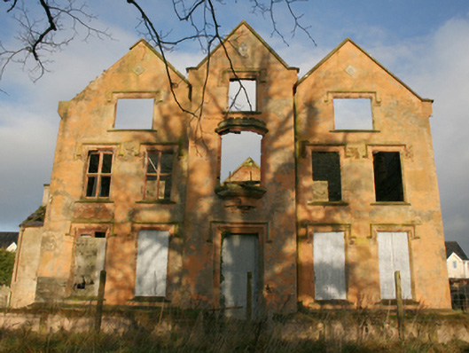
Detached five-bay three-storey over basement former county house, built c. 1770 and altered c. 1830, having three gables to entrance front (east) with central projecting gable-fronted breakfront having oriel window at first floor level, four-storey over basement block to west elevation, three-bay three-storey over basement elevation to east having half-dormer openings to south and three-storey gable-fronted projection to the north with single-storey canted bay window at ground floor level, single-storey multi-bay bay to rear (west), and two-bay two-storey block to north-west corner. Now a ruin following fire in recent years. Collapsed pitched natural slate roofs. Cut stone eaves course with corbelled sandstone brackets, cut stone coping over gable-fronted bays and half-dormer openings having kneeler stones at eaves level, and with remains of brick and rendered chimneystacks. Smooth rendered ruled-and-lined walls over moulded ashlar plinth course at ground floor level; brick construction evident to interior, rubble stone construction evident in places. Carved decorative plaques to gable apexes to front elevation, one inscribed ‘Bon Fido’. Square-headed window openings with remains of timber casement windows with mullion and transoms, chamfered stone sills, ashlar sandstone hoodmouldings, and chamfered reveals. Square-headed window openings to block to the south-west having remains of timber sliding sash windows. Ashlar corbelling to base of oriel window with moulded cornice over. Square-headed doorway to the centre of the east elevation having staged ashlar sandstone surround, hoodmoulding over, and with remains of timber panelled double-doors; doorway now blocked. Set back from road in own grounds with modern housing development encroaching to the north, remnant gardens to front (east) and south, remnant woodland to east, rubble stone boundary wall to north, and remnant driveway to east. Detached two-storey outbuilding (on U-shaped plan) to the north-east, now also ruinous, having now largely collapsed pitched natural slate roofs with cut stone eaves, roughcast rendered chimneystacks, and gable-fronted half-dormer openings to block to the west. Rubble stone walls with remains of lime render over. Square-headed window openings with red brick reveals, cut sandstone sills, remains of timber windows, and with timber louvered fittings to half-dormer openings. Square-headed door openings with red brick surrounds, and remains of timber doors and overlights. Segmental-headed carriage-arches with red brick surrounds (some now infilled). Altered single-storey with dormer attic level gate lodge to the east, built c. 1830, now converted for use as a public house and extended. Detached single-storey former gate lodge to the south-west, now ruinous, having central gable-fronted porch to the front elevation (north-west) and canted bay window to the south-west gable end. Pitched slate roofs with central rendered chimneystack, square-headed window openings to main body of building with remains of timber windows; round-headed window opening to the south-west side of porch having remains of timber windows with timber tracery. Recessed round-headed doorway with remains of timber fittings.
This official record and map point do not grant access. Most recorded buildings are privately owned; view them only from public ground unless the owner allows entry.