Add your own picture and explain the route, parking, gates, paths or landmarks that help people find it.
Earn 5 points after the picture is checked and accepted.
Add your photo and local directionsShare what you foundWhat is recorded here
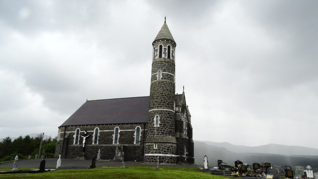
Freestanding gable-fronted Hiberno-Romanesque Catholic church, built 1876-7, having round-plan tower to north, sacristy to southwest and apse to southeast. Pitched banded purple and grey slate roof with semi-cone over sanctuary, ashlar copings to gable-front with cross finial, cast-iron profiled gutters and hoppers, square-section downpipes, and scrolled dentillated eaves course. Conical stone roof to tower, with cross finial and scrolled dentillated eaves course. Pitched slate roof to sacristy, with ashlar copings and chimneystack with ashlar skews, chamfered coping and clay pot to gable with scrolled dentils. Coursed limestone walls with tooled granite sill course to nave and white quartzite string course at springing level, buttresses with granite skews to gable-front having granite cut-stone clock-face and roof with cross finial, and round-headed niche within pointed-arch raised white quartzite surround with statue inset. Coursed limestone walls to tower, with projecting plinth having slate canted course with white quartzite and granite tooled string courses. Granite kneeler stones to sacristy. Round-headed window openings with chamfered white quartzite surrounds, granite integral sills and leaded stained glass with secondary glazing. Round-headed openings to gable-front, flanking niche, and round-headed belvedere to top stage of tower. Round-headed entrance with white quartzite moulded colonnettes to cut-stone surround with hood-moulding, and timber battened double-leaf door. Plain interior, with timber boarding to vaulted ceiling and exposed braced-arch timber trusses with paired colonnettes supporting chancel truss. Set in rural landscape, with An Earagail [Errigal Mountain] to the east and Loch na Cuinge Uachtarach [Lough Nacung Upper] to the west, surrounded by graveyard with recent boundary walls and gate.
This official record and map point do not grant access. Most recorded buildings are privately owned; view them only from public ground unless the owner allows entry.