Add your own picture and explain the route, parking, gates, paths or landmarks that help people find it.
Earn 5 points after the picture is checked and accepted.
Add your photo and local directionsShare what you foundWhat is recorded here
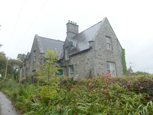
Detached five-bay single-storey house with attic level, built c. 1875, having central advanced single-bay single-storey with attic level gable-fronted breakfront to the centre of the main elevation (south) having attached single-bay single-storey porch with mono-pitched roof attached to the east side, three-gable-fronted half-dormer openings to the front elevation (south), to single-storey with attic level returns to the rear (north). Probably originally associated with Mulroy House (see 40901712), later in use as a private house, renovated c. 2011. Pitched natural slate roof with cut stone coping and kneeler stones to the east gable end and to central breakfront, raised render verges with kneeler stones to west gable end and to half-dormer windows, single two-stage ashlar chimneystack with cut stone coping to the east side of breakfront, and single ruled-and-lined smooth rendered chimneystack to the west gable end. Cut stone coping and kneeler stones to a number of half-dormers openings to the east end and to the east side of rear return. Cut stone corbelling to base of a number of half-dormer openings to the east end of building and to the east side of rear return. Coursed rubble stone walls to central breakfront, east side of front elevation, to porch, to east gable end, and to east elevation of rear return. Smooth rendered ruled-and-lined walls to other elevations. Raised cut stone plinth course. Square-headed window openings with two-over-two and with single and paired one-over-one pane timber sliding sash windows. Tooled stone reveals and integral chamfered cut stone sills to east side of front elevation, east side of return, and to central breakfront to main elevation; stone sills to number of the window openings to the west side of front elevation and to ancillary elevations. Some timber casement windows to the rear elevation. Tudor-arched door opening to the east elevation of front porch having chamfered cut stone surround and timber palled door; square-headed door opening to the rear with timber panelled door. Set back from road with small garden to the front (south). Located to north side of road leading to Mulroy Pier (see 40901766). Rubble stone boundary wall along the road to the south with pedestrian gateway comprising a pair of rubble stone gate piers (on square-plan) serving main doorway. Ruinous single-storey outbuilding to the north. Located to the north\north-west of Mulroy House and to the east of Carrickart overlooking Mulroy Bay to the north.
This official record and map point do not grant access. Most recorded buildings are privately owned; view them only from public ground unless the owner allows entry.