Add your own picture and explain the route, parking, gates, paths or landmarks that help people find it.
Earn 5 points after the picture is checked and accepted.
Add your photo and local directionsShare what you foundWhat is recorded here
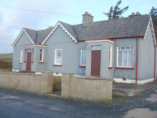
Detached six-bay single-storey house and former shop, built c. 1930, comprising three-bay single-storey house to the west having central single-bay flat-roofed entrance porch to the main elevation (south) flanked to either side by gable-fronted bays, and with three-bay single-storey former shop to the east having central single-bay flat-roofed entrance porch to the main elevation (south). Gable-fronted bay to the north end of the west side elevation. Now out of use. Pitched artificial slate roofs (felt tiles) with clay ridge tiles, decorative wavy timber bargeboards to gable-fronted bays, cast-iron rainwater goods, and with three cement rendered chimneystacks. Painted corrugated-metal clad walls over cement rendered plinth course. Square-headed window openings to former house having concrete sills and one-over-one pane timber sliding sash windows with margin glazing bars; square-headed window openings to former shop having fixed-pane timber display windows with multi-paned overlights. Square-headed window openings to side elevations of porch having timber casement windows. Square-headed doorway to the front elevation (south) of porch serving house to the west having battened timber door, sidelights, and overlight; square-headed doorway to the front elevation of porch to former shop having battened timber door and overlight with painted lettering reading ‘John Marrow Grocery and Hardware’ and ‘Licensed to Sell Tobacco’. Concrete steps serving doorways. Set slightly back from road in slightly elevated site to the west of Carrickart, and to the south-west end of the Fanad Peninsula overlooking Mulroy Bay to the south. Roughcast rendered boundary wall to road-frontage to the south having concrete coping over. Pedestrian gateways serving both doorways comprising a pair of roughcast rendered gate piers (on square-plan) having pyramidal concrete coping over. Vehicular entrance to the east end of boundary wall to front having gravelled forecourt to the north. Hedgerow to west boundary and rubble stone boundary wall to east boundary. Overgrown garden to site.
This official record and map point do not grant access. Most recorded buildings are privately owned; view them only from public ground unless the owner allows entry.