Add your own picture and explain the route, parking, gates, paths or landmarks that help people find it.
Earn 5 points after the picture is checked and accepted.
Add your photo and local directionsShare what you foundWhat is recorded here
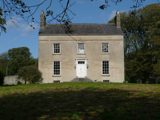
Detached three-bay two-storey over basement with attic level former Church of Ireland rectory on ‘L-shaped’ plan, built c. 1795, having six-bay two-storey return and service wing to north with integral segmental-headed carriage-arch. Now in use as a house with accommodation to former service wing. Pitched natural slate roof to main body of building having stone eaves course, stone ridge tiles, cast-iron rainwater goods, and with two stage smooth rendered chimneystacks to gable ends with stepped coping and decorative clayware pots over. Pitched rough-hewn natural slate roof to former servant quarters with cast-iron rainwater goods. Roughcast rendered walls with projecting cut stone string course over first floor openings to the south elevation, smooth rendered ruled-and-lined rendered walls to east gable elevation, roughcast rendered walls to north. Roughcast rendered walls to service wing. Square-headed window openings having stone sills, and with nine-over-six pane timber sliding sash windows at ground floor level and six-over-six pane timber sliding sash windows over at first floor level. Square-headed window openings elsewhere with a variety of timber sliding sash windows; single round-headed window opening to centre of rear elevation lighting stair hall. Square-headed window openings to service wing having mainly replacement casement windows. Square-headed doorway to the centre of the main elevation (south) having timber panelled door, architraved surround, flanking timber pilasters with console brackets over supporting timber entablature over, plain three-pane overlight, and with cut stone plinth blocks to base. Doorway approached by flight of cut stone steps. Wrought-iron gates to carriage-arch to service wing. Set back from road in mature site having lawns and mature trees to south and west. Yard to the rear enclosed to the east by service wing and to the east by rubble stone boundary wall. Ruinous single-storey outbuilding to west\north-west of site having remains of pitched natural slate roof, roughcast rendered rubble stone walls, square-headed window openings with brick reveals and remains of timber fittings, and segmental-headed carriage-arch; modern outbuilding attached. Former walled garden (see 40901737) to the north of house having rubble stone boundary walls; gateway to the south having a pair of rubble stone gate piers (on circular-plan) with rubble stone capping. Main entrance to the south (pre-1836) having a pair of rubble stone gate piers (on square-plan) having ball finials over; gateway flanked to either side by curved sections of rubble stone boundary wall. Secondary gateway to the west of house (post 1836) comprising a roughly squared and coursed gate piers (on square-plan) with stepped capping over. Rubble stone boundary walls to road-frontage to the west. Located in elevated site to the north of Rosnakil and Tamney, and to the east of Lagmore Bay on the south-west end of the Fanad Peninsula. Associated Church of Ireland church (see 40901701) located to the south.
This official record and map point do not grant access. Most recorded buildings are privately owned; view them only from public ground unless the owner allows entry.