Add your own picture and explain the route, parking, gates, paths or landmarks that help people find it.
Earn 5 points after the picture is checked and accepted.
Add your photo and local directionsShare what you foundWhat is recorded here
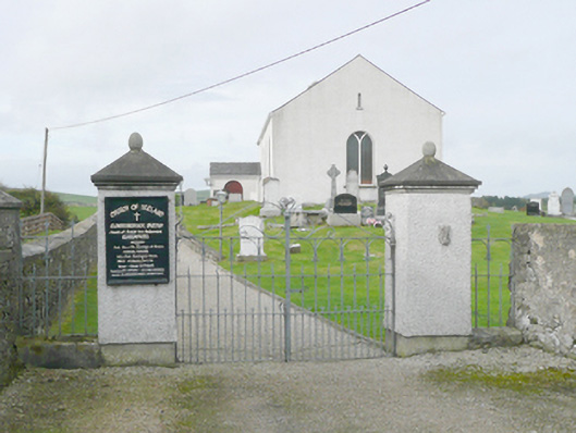
Detached double-height hall-type Church of Ireland church, built c. 1610 and altered 1693, c. 1830 and 1868, comprising a three-bay hall with single-bay single-storey entrance porch attached to the south-west corner, and with modern single-bay single-storey toilet extension attached to the west gable end. Refurbished c. 1990. Pitched natural slate roof with concrete ridge tiles, rendered bellcote to west gable end with bell metal bell, projecting eaves courses, and having replacement rainwater goods. Pitched artificial slate roof to entrance porch and mono-pitch natural slate roof to toilet extension. Pebbledashed walls over smooth rendered plinth course, memorial stone incorporated into south elevation. Round-headed window openings with cut stone sills and replacement windows. Round-headed door opening to east elevation of entrance porch having double timber sheeted door. Central window opening to east (chancel) elevation having leaded stained glass inset with secondary window over; ventilation opening to attic above. Hall-type interior having gallery supported on metal columns to the west end having timber panelled balustrade with pointed-arched motifs, timber pews and various stone and marble memorials throughout. Set back from road in own grounds to the south-west of Rosnakil and to the north-east of Carrigart on the south-wet end of the Fanad Peninsula. Graveyard to site containing collection of upstanding and recumbent memorials dating from the seventeenth century; some memorials in railed enclosures, number of table and mausolea-type memorials to site. Graveyard (on rectangular-plan) bounded by rubble stone boundary walls. Main gateway to the south-east corner of site comprising a pair of pebbledashed gate piers (on square-plan) having pyramidal capping over, and with a pair of modern metal gates. Carved mask\head motif built into the eat face of pier of the north. Short approach laneway to the east from main road.
This official record and map point do not grant access. Most recorded buildings are privately owned; view them only from public ground unless the owner allows entry.