Add your own picture and explain the route, parking, gates, paths or landmarks that help people find it.
Earn 5 points after the picture is checked and accepted.
Add your photo and local directionsShare what you foundWhat is recorded here
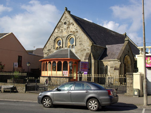
Detached five-bay single-storey former Methodist chapel, dated 1888, having gable-fronted porch attached to the south end of the east of nave. Now in use as a restaurant with modern glazed lean-to entrance porch attached to the south gable end and extensions to the east and west elevations of nave. Pitched natural slate roof with rasied ashlar sandstone gable copings having fleur-de-lis finials over gable apexes (main body of building and to porch), moulded sandstone kneeler stones to gables and having moulded (cavetto) eaves course to east and west elevations. Replacement rainwater goods. Rendered chimneystacks to gable ends of main body of building. Snecked squared rubble sandstone walls having flush squared dressed sandstone quoins to corners. Stepped clasping buttresses to corners having ashlar coping over and ashlar quoins. Paired round-headed window openings to nave elevations and to south gable end having moulded sandstone surrounds, leaded coloured glass windows, cut stone plate tracery with round top light, and cut stone hoodmouldings over with foliated label stops. Windows to nave side elevation now largely obscured by modern extensions; window openings to south gable now partially infilled and obscured by modern porch. Oculus open with chamfered cut stone surround to gable apex to south. Square-headed window opening to south face of porch having chamfered cut sandstone reveals and leaded coloured glass windows. Square-headed door opening to east face of porch having chamfered dressed sandstone surround with shouldered lintel, and timber panelled door. Carved semi-circular memorial and date plaque over doorway having cut stone hoodmoulding over with foliated label stops. Set back from the street on raised site towards the centre of Bundoran having tarmac forecourt to south. Concrete steps to site. Squared rubble stone plinth boundary wall to road-frontage to the south having chamfered dressed stone coping and cast-iron railings over having fleur-de-lis finials. Boundary wall to road-frontage terminated to either end (south-west and north-east) by squared coursed dressed sandstone piers (on square-plan) having chamfered coping over. Gateway to south having paired cast- and wrought iron gates with fleur-de-lis finials over; pedestrian gateway to the east end of boundary wall having cast- and wrought iron gate with fleur-de-lis finals over and open iron gate post to the west end having urn finials over. Rubble sandstone boundary wall to the east side of site having crenellated coping over.
This official record and map point do not grant access. Most recorded buildings are privately owned; view them only from public ground unless the owner allows entry.