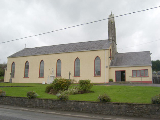
Add your own picture and explain the route, parking, gates, paths or landmarks that help people find it.
Earn 5 points after the picture is checked and accepted.
Add your photo and local directionsShare what you foundWhat is recorded here
Freestanding double-height Catholic church, built c. 1810 and altered c. 1880, in 1920 and c. 1980, comprising six-bay hall having cut stone bellcote over the north-east gable end, shallow single-bay sacristy to the south-east and having modern two-bay single-storey porch extension to the north-east. Modern single-storey confessional offshoots to the north-west elevation of hall. Pitched natural slate roofs having metal cross finial over south-west gable end of hall. Roughcast rendered walls over projecting smooth rendered plinth course; cement rendered walls to the north-west elevation of hall. Stepped ashlar buttress/frontispiece to the north-east end of hall having steeped ashlar pilasters with feathered ashlar coping over, ashlar stringcourse, pointed-arched opening containing bell at belfry level, and with cut stone cross finial over. Pointed-arched window openings to south-east elevation of main hall having smooth rendered reveals, having modern leaded stained glass windows. Blank elevation to the north-west side of hall. Square-headed window openings to modern porch extension to the north-east. Square-headed door opening to south-east face of porch having with timber double-doors; round-headed door opening to south-east elevation of sacristy having timber door and leaded overlight. Interior re-ordered c. 1980. Set back from road in own grounds on sloping site to the west/south-west of Pettigoe. Graveyard to the north-west and north having mainly twentieth-century gravemarkers. Carpark to the north-east of site. Rubble stone boundary wall to road-frontage to the south-east. Rubble stone boundary walls to rear of site.
This official record and map point do not grant access. Most recorded buildings are privately owned; view them only from public ground unless the owner allows entry.