Add your own picture and explain the route, parking, gates, paths or landmarks that help people find it.
Earn 5 points after the picture is checked and accepted.
Add your photo and local directionsShare what you foundWhat is recorded here
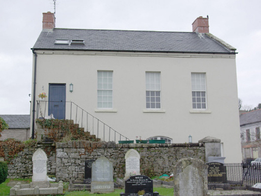
Detached four-bay two-storey gable-fronted former court house and dispensary, built c. 1850, having flight of external cut stone steps to the east elevation giving access to door at first floor level. Possibly formerly in use as a market house to the ground floor; formerly also in use as a retail outlet. Renovated c. 2005. Pitched natural slate roof (replacement) having raised ashlar verge to the north gable end and with red brick chimneystacks to either gable end (north and south). Modern rooflights. Projecting eaves course brought across gable-fronted north elevation as stringcourse. Smooth rendered walling. Square-headed window openings at first floor level with replacement nine-over-nine pane horned timber sash windows and stone stills; square-headed window opening to the east elevation having replacement six-over-three pane timber sliding sash window; central segmental-headed window opening to the north elevation at ground floor level having replacement tripartite nine-over-nine pane horned timber sash windows. Segmental headed opening to the east elevation having paired timber windows. Square-headed door openings to the north elevation, flanking central window, having replacement glazed doors. Square-headed doorway to the east elevation at first floor level having replacement timber battened door; door accessed by flight of tooled stone steps having wrought-iron railings. Road-fronted to the west of Pettigoe town centre and adjacent to the west of Pettigoe Church of Ireland church. Section of rendered boundary wall adjacent to the west having integral segmental-headed carriage-arch with tooled ashlar voussoirs and surrounds, and wrought-iron gates. Garden to the rear (south) and small enclosed yard to the west. Rubble stone boundary walls to site.
This official record and map point do not grant access. Most recorded buildings are privately owned; view them only from public ground unless the owner allows entry.