Add your own picture and explain the route, parking, gates, paths or landmarks that help people find it.
Earn 5 points after the picture is checked and accepted.
Add your photo and local directionsShare what you foundWhat is recorded here
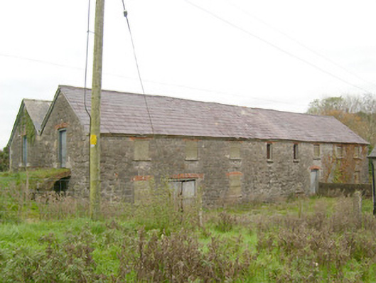
Complex of former corn and saw mill buildings, built c. 1820 and extended in 1851, comprising main eight-bay two- and storey building to building to the north and three-bay three-storey building to the south. Later also in use as a power generation station c. 1930 – 1962. Now out of use. Possibly incorporating fabric from earlier corn mill to site in existence in 1756. Brick and stone bridge over basement level to north-east elevation of main building, giving access to entrances to upper storey. Cut stone and brick bridge over basement level to three-storey building to the south. Remains of iron mill wheel with timber paddles and associated machinery to south-east corner of main building; mill wheel set in wheel pit with rubble stone retaining walls. Pitched natural slate roofs with clay ridge tile, projecting stone eaves courses, and some remaining sections of cast-iron rainwater goods. Coursed squared rubble stone walls having flush ashlar block-and-start quoins to the corners. Shallow segmental-headed windows having stone sills, red brick voussoirs and with remains of multi-pane timber sliding sash windows. Segmental-headed door openings having red brick voussoirs and remains of timber sheeted doors and double-doors. Cut stone surrounds and cut stone plinth blocks to a number of doorways. Set back from road in extensive grounds on the west bank of the Termon River. Site slopes from the west to the east towards the river. Located to the north of Pettigoe. Rubble stone walls and remains of buildings, now demolished, to site. Remains of former weir to the north-east of complex. Former offices (see 40850002 located adjacent to the south-west. Rubble stone boundary wall with rounded rock-faced coping over to road-frontage to the west and south-west. Gateways to the north and south ends of boundary wall comprising a pair of ashlar stone gate piers (on square-plan) having cut stone coping over with stone ball finials; wrought-iron flat bar gates.
This official record and map point do not grant access. Most recorded buildings are privately owned; view them only from public ground unless the owner allows entry.