Add your own picture and explain the route, parking, gates, paths or landmarks that help people find it.
Earn 5 points after the picture is checked and accepted.
Add your photo and local directionsShare what you foundWhat is recorded here
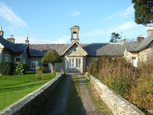
Detached nine-bay single-storey with attic level former national schools on U-shaped plan, built 1851 and 1860, having advanced gable-fronted two-storey projections to either end of the front elevation (south-east) with projecting gable-fronted entrance porch projections to inner faces facing each other across forecourt, and with central gable-fronted bay having cut stone bellcote over. Section to the south-west now in use as a dwelling and holiday apartment; section to the north-east now out of use. Canted bay window openings with flat roofs, and having moulded cut stone cornices over lintel with cut stone blocking course over to the central gable-fronted bay and to south-east gable ends of end projections. Central projecting bay to the rear elevation (north-west) having canted bay window to front face (north-west). Pitched natural slate with overhanging eaves, and having ashlar chimneystacks with cut stone cornices to coping and terracotta chimneypots. Timber boarded soffits to eaves; some surviving sections of cast-iron rainwater goods. Modern rooflights to front pitch of section to the south-west with modern dormer openings to rear pitch. Ashlar bellcote (on square-plan) over central bay with ogee-headed openings at belfry level having cut stone stringcourse to base and moulded cut stone stringcourse over, and with domed capping over. Coursed and squared rubble stone walls with flush dressed ashlar limestone quoins to the corners. Square-headed window openings having ashlar limestone block-and-start surrounds, ashlar lintels and sills, hoodmouldings and with one-over-one pane timber sliding sash windows (in groups of two, three and four in places). Circular/oculus openings with cut stone surround to gable apex of central bay to the front and rear elevations. Ashlar mullions to corners of canted bay windows. Square headed door openings to south-east faces of porch projections having timber panelled doors with overlights. Square-headed door openings to side elevations of central projecting bay. Set back from road on an elevated site overlooking Killybegs harbour to the east/south-east; located to the north-east of Killybegs town centre. Garden to front of site and yards to rear (north-west). Rubble stone boundary walls to site boundary having rubble coping over. Rubble stone boundary walls with cut stone coping over aligning path from main gateway to central bay. Cut stone steps in grounds. Main gateway to the south-east comprising a pair of ashlar gate piers (on square-plan) having pyramidal capstones over, and with a pair of hooped wrought-iron gates with decorative finials.
This official record and map point do not grant access. Most recorded buildings are privately owned; view them only from public ground unless the owner allows entry.