Add your own picture and explain the route, parking, gates, paths or landmarks that help people find it.
Earn 5 points after the picture is checked and accepted.
Add your photo and local directionsShare what you foundWhat is recorded here
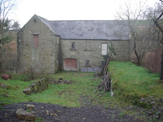
Detached four-bay two-storey corn/oat mill on L-shaped plan, built c. 1800 and extended c. 1860, having single-bay two-storey block to the south-west corner. Iron breastshot waterwheel attached to the east gable end of original building. Now disused (since c. 1954). Pitched natural slate roofs purple with raised ashlar verges to gable ends having cut stone kneeler stones at eaves level, and with cast-iron rainwater goods. Rubble stone walls with cast-iron pattrice plates; rock-faced quoins to corners of original building. Square-headed window openings with rock-faced stone lintels, stone sills, and fixed timber windows. Some window openings now blocked. Square-headed door opening to east end of south elevation at first floor level having timber door; opening now boarded. Doorway reached up rubble stone ramp from the south. Square-headed loading bay to the south gable end of extension to the south-west corner having timber sheeted door and remains of metal winch mechanism over to gable apex. Segmental-headed carriage arch to the south elevation of original block having rock-faced stone voussoirs and timber double-doors. Set back from road in own grounds to the east of Cill Chartha/Kilcar; Glenaddragh River adjacent to the north. Former millpond adjacent to the south-east; rubble stone retaining walls and boundary walls to site. Concrete retaining walls to former raised headrace having remains of metal sluice mechanism adjacent to mill wheel. Remains of machinery including mill stones and kiln with furnace to interior. Flagstone floor to interior.
This official record and map point do not grant access. Most recorded buildings are privately owned; view them only from public ground unless the owner allows entry.