Add your own picture and explain the route, parking, gates, paths or landmarks that help people find it.
Earn 5 points after the picture is checked and accepted.
Add your photo and local directionsShare what you foundWhat is recorded here
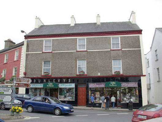
End-of-terrace three-bay three-storey house, built c. 1860, with later Vitrolite shopfront to ground floor, added c. 1950. Pitched artificial slate roof (fibre cement) with slightly sprocket eaves, four rendered chimneystacks (two to centre and one to either gable end), profiled metal gutters and cast-iron downpipes. Dentilated eaves cornice/course with paired brackets over supporting gutter. Roughcast rendered walls with smooth rendered bands to the margins, smooth rendered band above second floor window openings, smooth rendered sill course at first floor level, and with render/stucco cornice above shopfront. Square-headed window openings to upper floors having rendered reveals, stone sills, and with one-over-one pane timber sliding sash windows to upper floor and replacement fittings at first floor level. Square-headed display windows to shopfront having chrome surrounds. Central square-headed doorway to the main elevation having replacement timber panelled door with overlight. Recessed square-headed doorway to shopfront to the east end of the main elevation (north-west); square-headed doorway to the shopfront to the west end of the main elevation. Black Vitrolite cladding at ground floor level having chrome detailing and raised chrome lettering to fascia to the eastern shopfront. Building faces onto easternmost angle of The Diamond in the centre of Donegal Town. Outbuildings to the rear (south-east).
This official record and map point do not grant access. Most recorded buildings are privately owned; view them only from public ground unless the owner allows entry.