Add your own picture and explain the route, parking, gates, paths or landmarks that help people find it.
Earn 5 points after the picture is checked and accepted.
Add your photo and local directionsShare what you foundWhat is recorded here
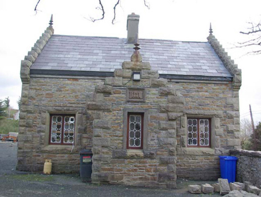
Detached three-bay two-storey former gate lodge associated with Carrick Lodge (see 40842001), built c. 1867, having projecting single-bay gable-fronted entrance porch to the main elevation (west), and single-storey blocks to the rear (east/south-east), probably formerly in use as outbuildings. Now in use as a private house. Pitched natural slate roof having rusticated/rock-faced crow-stepped sandstone parapets (drafted margins) to the gable ends of main block (north and south), to front elevation of entrance porch to west, and to either gable end of block to the rear (east/south-east), with decorative cast-iron finials over to the gable apexes; cut sandstone kneeler stones to gable ends at eaves level. Rendered chimneystack to the centre of the main block. Mono-pitched natural slate roof to single-storey block to the rear of main block. Squared and randomly coursed rubble sandstone walls having rusticated/rock-faced ashlar sandstone block-and-start quoins to the corners having drafted margins. Sandstone plaque to front face of porch with raised ‘M M’ monogram. Square-headed window openings having rusticated/rock-faced ashlar sandstone block-and-start surrounds, chamfered cut sandstone reveals, and decorative bi- and tripartite cast-iron windows in timber frames. Square-headed doorway to the north face of porch having timber door. Square-headed door opening to rear having replacement glazed timber door. Located adjacent to roadway to the south of Carrick Lodge (see 40842001) at the start of long approach avenue to house, and to the west of An Charraig/ Carrick. Gateway to house adjacent to the west comprising a pair of rock-faced ashlar sandstone gate-piers (on square-plan) having drafted margins, and with capstone over; pier to the east now damaged. Similar gate adjacent to the east. Coursed squared sandstone boundary walls to site (south elevation of gate lodge forming part of wall) having rock-faced coping over.
This official record and map point do not grant access. Most recorded buildings are privately owned; view them only from public ground unless the owner allows entry.