Add your own picture and explain the route, parking, gates, paths or landmarks that help people find it.
Earn 5 points after the picture is checked and accepted.
Add your photo and local directionsShare what you foundWhat is recorded here
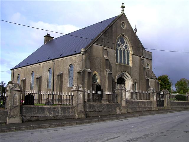
Detached four-bay single-storey gable-fronted Presbyterian church/meeting house, built 1903, with offset two-stage tower/stair tower attached to the north corner of the entrance front (east) having first stage on square-plan with second stage over on octagonal-plan. Single-storey vestry attached to the west elevation. Pitched artificial slate roof to main body of building having raised render coping to the front (east) with decorative cut stone (?) finial over gable apex and with kneeler stones at eaves level having gable-fronted blocks over; rendered chimneystack to the west end of main body of building; rendered eaves course to the north and south elevations. Hipped artificial slate roof on octagonal-plan to tower, partially hidden behind raised rendered and ruled-and-lined parapet, having lead flashing and with decorative wrought-iron finial over. Mono-pitched artificial slate roof to vestry. Smooth rendered and smooth rendered ruled-and-lined walls over projecting rendered plinth course and with stepped clasping buttresses between bays to side elevations of main body of building (north and south) having feathered skews/coping, stepped clasping buttresses to corners of front elevation (east) and to either side of main doorway having feathered skews/coping. Moulded render stringcourse to front elevation. Moulded render stringcourse to tower, delineating stages; angled feathered skews to corners of tower at second stage level. Pointed-arched window openings to side elevations (north and south) of main body of building and to the north elevation of tower at first stage level having leaded coloured glass windows; pointed-arched window openings to front elevation (east), flanking doorway, having raised rendered block-and-start surrounds with chamfered reveals, and with leaded coloured glass windows; trefoil window openings to the south end of the front elevation (east), below gable apex to the front elevation, and to the east and north elevations of tower at second stage level, having chamfered ashlar surrounds (generally round, triangular surround to the window opening to the south end of the front elevation), cut stone tracery and with leaded coloured glass windows; four-light pointed-arched window opening over main doorway to front elevation having cut stone Decorated Gothic tracery with geometric motifs, chamfered ashlar surround, leaded coloured glass windows, and with hoodmoulding over with decorative label stops; round window opening to west gable end having leaded coloured glass windows. Tudor-arched/four-centred arched doorway to the centre of the east elevation having splayed render surround with projecting splayed render blocks to base having inset pointed-arched recesses, timber double-doors with decorative wrought-iron hinges, haunched timber lintel with craved detailing, overlights with timber tracery and leaded stained glass, and with hoodmoulding over having decorative label stops. Set slightly back from road in own grounds to the north-east of the centre of Convoy, and adjacent to the north of the associated Presbyterian hall (see 40832014), dated 1910; graveyard to site having mainly twentieth-century memorials. Bounded on street-frontage to the east by rendered boundary wall having wrought-iron railings over with decorative finials, and with rendered gate piers (on square-plan) along length having recessed pointed-arch motifs to front faces and rendered capstones over with four gable-fronted faces having recessed trefoil motifs. Gateway to the centre, serving main doorway, having a pair of rendered gate piers (on square-plan) having recessed pointed-arch motifs to front face, rendered capstones over with four gable-fronted faces having recessed trefoil motifs, and with a pair of wrought-iron gates. Rubble stone to other site boundaries. Possible remains of former sexton’s house or manse to the north-west of site.
This official record and map point do not grant access. Most recorded buildings are privately owned; view them only from public ground unless the owner allows entry.