Add your own picture and explain the route, parking, gates, paths or landmarks that help people find it.
Earn 5 points after the picture is checked and accepted.
Add your photo and local directionsShare what you foundWhat is recorded here
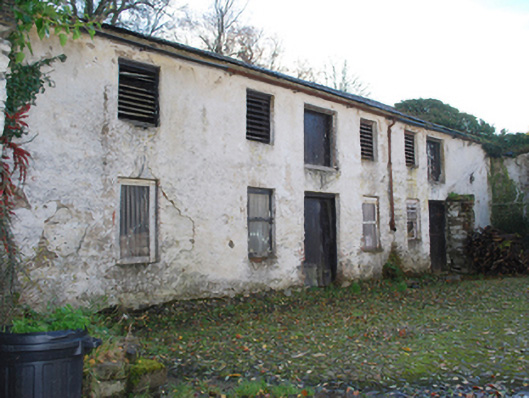
Complex of single- and two-storey outbuildings associated with The Deanery Glendooen\Conwal Church of Ireland Rectory (see 40829011), built c. 1816, comprising six-bay two-storey building to the south-east, five-bay two-storey building to the north-west, two single-storey outbuildings to the south-west (block to the south-west corner now collapsed), and with integral segmental-headed carriage arch to the centre of the south-west elevation. Now out of use/dilapidated. Pitched natural slate roof to building to the south-east having projecting cut stone eaves course, remains of cast-iron rainwater goods, and with rendered rubble stone and brick bellcote to the north-east gable end having bell metal bell. Pitched corrugated-metal roof to building to the north-west having projecting eaves course. Pitched natural slate roof to surviving single-storey block to the west having projecting eaves course. Lime rendered rubble stone walls. Square-headed window openings to outbuilding to the south-east with slate sills and remains of timber windows at ground floor level and timber louvered fittings at first floor level. Square-headed window openings to outbuilding to the north-west having remains of timber fittings. Loop hole openings to single-storey building. Square-headed doorways with battened timber doors, doorways to outbuilding to the north-west now removed. Arranged around a courtyard to the south-west of The Deanery Glendooen\Conwal Church of Ireland Rectory (see 40829011). Walled garden with rubble stone boundary walls to the south-west. Sections of rubble stone boundary walls to the north-east of courtyard. Section of rubble stone boundary wall to the south-west elevation having integral segmental-headed carriage-arch with brick voussoirs. Set back from road in extensive mature grounds in the rural countryside to the south-west of Letterkenny and a short distance to the north-east of Newmills Bridge.
This official record and map point do not grant access. Most recorded buildings are privately owned; view them only from public ground unless the owner allows entry.