Add your own picture and explain the route, parking, gates, paths or landmarks that help people find it.
Earn 5 points after the picture is checked and accepted.
Add your photo and local directionsShare what you foundWhat is recorded here
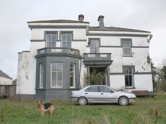
Detached three-bay two-storey house on L-shaped plan, built 1875, having advanced two-storey bay to the north end of the front elevation (west) having canted bay window at ground floor level with flat-roof over having balustraded parapet with inset decorative cast-iron railing, open single-bay porch to the centre of the front elevation (west) having balcony over with balustraded parapet having with inset decorative cast-iron railing, shallow projection to the north elevation having box bay window with paired window openings with raised parapet over having with inset decorative cast-iron railing, two-storey canted bay window to the south elevation having decorative cast-iron ridge cresting over, and with two-storey return to the rear (east). Low hipped natural slate roof having overhanging eaves with smooth rendered eaves course, central pair of stepped rendered chimneystacks with smooth rendered coping and polygonal pots over, and with stepped rendered chimneystacks with smooth rendered coping and polygonal pots over to the rear return and to the rear pitch of roof to the south. Rendered coping over box bay window to the north. No rainwater goods. Roughcast rendered walls over smooth rendered plinth course, smooth rendered walls to canted bay windows, and with smooth rendered moulded stringcourses at ground and first floor levels brought over top of window openings as architraved heads. Square-headed window openings with two-over-two pane horned timber sliding sash windows; single timber casement window and single eight-over-eight pane horned timber sliding sash window to west elevation. Segmental-headed door opening to porch having glazed timber panelled door flanked by sidelights and overlight, and with encaustic tiled threshold. addressed by concrete steps to east of porch. Set back from road in own grounds to the south-west of Carrigans, and a short distance to the north of the River Foyle and the former Carrigans Railway Station. Complex of ruinous two-storey outbuildings to the north-east having remains of (pitched?) natural slate roofs, partially rendered rubble stone walls, and with square-headed openings (now blocked). Gateway to the south-west of site comprising a pair of smooth rendered piers (on square-plan) having chamfered edges, smooth rendered plinth course and pyramidal coping, and with a pair of hooped wrought-iron gates.
This official record and map point do not grant access. Most recorded buildings are privately owned; view them only from public ground unless the owner allows entry.