Add your own picture and explain the route, parking, gates, paths or landmarks that help people find it.
Earn 5 points after the picture is checked and accepted.
Add your photo and local directionsShare what you foundWhat is recorded here
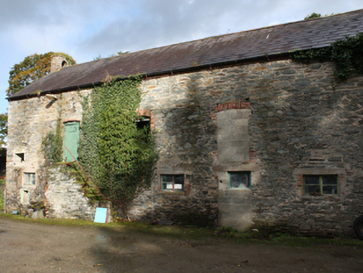
Group of detached single-, two- and three-storey outbuildings (including barn and stables) associated with Dunmore House (see 40828003), built c. 1800 and modified and altered on subsequent occasions. Arranged around a courtyard to the north of main house. Detached two\three-storey barn to the north of complex, single- and two-storey former stableblock to the west, and single-storey outbuilding to the east. External flight of rubble stone stairs to the south elevation of former barn to the north. Pitched and hipped natural slate roofs with blue-black and red clay ridge tiles, projecting cut stone and stepped brick eaves courses, and with some surviving sections of cast-iron rainwater goods. Brick bellcote to west gable end of three\two-storey outbuilding to the north of site. Rubble stone walls. Camber-headed and square-headed window openings, some with flush brick voussoirs and surrounds, some with cut stone sills, some with timber lintels, and with three and six-over-six and six-over-three pane timber sliding sash windows and replacement windows (generally timber casement windows). Camber-headed and square-headed door openings and loading bays having brick voussoirs, some with block-and-start brick surrounds, and with mainly battened timber doors and double-doors. Complex arranged around a gravel courtyard to the north of main house, and to the north-east of Carrigans. Mature trees to site; modern farmyard and buildings to the west and north-west of site.
This official record and map point do not grant access. Most recorded buildings are privately owned; view them only from public ground unless the owner allows entry.