Add your own picture and explain the route, parking, gates, paths or landmarks that help people find it.
Earn 5 points after the picture is checked and accepted.
Add your photo and local directionsShare what you foundWhat is recorded here
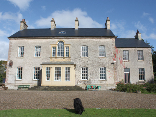
Detached five-bay two-storey over basement with attic level country house, dated 1742 and extended c. 1820 and c. 1848, having two-bay two-storey extension attached to the east side elevation, flat-roofed single-storey Doric entrance porch (c. 1820) to the centre of the original block, and with central two-storey over basement return to the rear (north). Various single- and two-storey additions to the rear (north). Pitched artificial slate roof (c. 2006) to main body of building having metal rooflight to south pitch, blue-black clay ridge tiles, four yellow brick chimneystacks (one to either gable end and two to the centre) having brick stringcourses, moulded cement rendered cornices and decorative octagonal clay pots, and with moulded cut sandstone eaves course\cornice. Pitched artificial slate roof to extension to the east having rendered chimneystack to the east gable end, and with cut stone eaves course. Pitched slate roof to return\stair return having brick eaves course. Roughcast rendered walls to front elevation having chamfered rusticated ashlar sandstone block-and-start quoins to the corners, and with ashlar stone platband between basement and ground floor level. Smooth rendered walls to porch having rendered Doric pilasters supporting rendered moulded entablature with triglyphs to frieze and mutules to cornice. Roughcast rendered walls to extension to the east having block-and-start quoins to the corners at the east end. Camber-headed window openings with six-over-six pane timber sliding sash windows. Central Venetian window arrangement to the main block at first floor level having ashlar sandstone surround with moulded architraved surround with keystone detail over central round-headed window, moulded entablatures with pronounced cornices to flanking square-headed window openings, moulded continuous sandstone sill supported on stone corbels, and with timber sliding sash windows with radial head to central round-headed opening. Camber-headed window opening to the north gable end of stair return to rear (north) at ground floor (over basement) level having twelve-over-eight pane timber sliding sash window. Square-headed window openings to block to the east having six-over-six pane timber sliding sash windows with cement rendered reveals and stone sills. Square-headed window openings to front face of porch (south) having central six-over-six pane timber sliding sash windows flanked to either side by four-over-four pane timber sliding sash windows, and with rendered torus moulded corners to reveals and painted timber sills; square-headed window opening to the west elevation of porch (formerly a doorway) having timber four-pane window with decorative cast-iron overlight. Square-headed entrance door opening to the east elevation of porch having flat-panelled timber panelled door with bolection moulding, rendered torus moulded corners to reveals, and with decorative overlight with cast-iron tracery. Set back from road in an elevated site in extensive mature landscaped grounds to the north-east of Carrigans. House overlooks River Foyle and Northern Ireland to the south. Gravelled forecourt to the south of house, farmyard complex to north (see 40828004), and walled garden to the south-east (see 40828005) having collection of sundials (see 40828012), created c. 1935-6; rubble stone wall to south-west corner of house with remains of stone dressed arch and pier having stone plaque dated ‘1620’, ‘1678’, ‘1709’ and ‘1742’. Gateway (see 40828002) at start of long approach avenue to house from the south.
This official record and map point do not grant access. Most recorded buildings are privately owned; view them only from public ground unless the owner allows entry.