Add your own picture and explain the route, parking, gates, paths or landmarks that help people find it.
Earn 5 points after the picture is checked and accepted.
Add your photo and local directionsShare what you foundWhat is recorded here
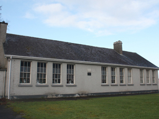
Detached eight-bay single-storey school, dated 1900 and extended c. 1950 with construction of additional three-bay single-storey classroom block to the north of the main body of the building and with addition of two single-storey flat-roofed blocks to the rear (west) at the south-west and north-west corners having recessed entrances to the east elevations. Single-bay single-storey flat-roofed outbuilding attached to the south-east corner. Now out of use\converted for use as a parochial hall. Pitched natural slate roof to main body of building having two roughcast rendered chimneystacks (one to the south-gable end and one to the original north end), clay ridge tiles, and with replacement rainwater goods. Flat felt roofs to recessed blocks to the rear. Roughcast rendered walls over smooth rendered plinth course. Cut stone name plaque (on rectangular-plan) to the original centre of the main body of building incised ‘Scoil Mhuire (Rát Mealltain) Social Náisiúnta; modern plaque to site reading ‘This plaque is dedicated to the past teachers and pupils of Scoil Mhuire Rath Mealltain 1900-1980’. Square-headed window openings to front elevation (east) and to the north and south having stone sills, smooth rendered reveals, and six-over-six pane timber sliding sash windows; window openings to rear now blocked. Square-headed door openings to the east elevations of recessed blocks to the rear (extended beyond north and south elevations of main body of building, acting as porches) having timber battened doors and raised smooth rendered surrounds; flat roofs of extensions continue forward to provide canopies over doorways supported on reinforced concrete posts. Set back from road in own grounds to the south-west of the centre of Ramelton, and adjacent to the west of St. Mary’s Catholic church (see 40800304). Rubble sandstone boundary walls to site with sandstone pyramidal coping over. Pedestrian gateway at roadside to the south-west having a pair of coursed rubble stone gate piers (on square-plan) having chamfered sandstone coping over, and with wrought-iron flat bar gate.
This official record and map point do not grant access. Most recorded buildings are privately owned; view them only from public ground unless the owner allows entry.