Add your own picture and explain the route, parking, gates, paths or landmarks that help people find it.
Earn 5 points after the picture is checked and accepted.
Add your photo and local directionsShare what you foundWhat is recorded here
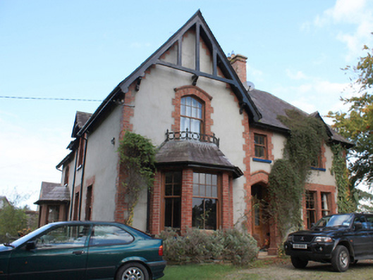
Detached three-bay two-storey former Church of Ireland rectory on complex irregular-plan, built 1888, having advanced gable-fronted bay to the south-end of the main elevation (east) with single-storey canted bay window at ground floor level having decorative cast-iron balustrade\railing over,, gabled half-dormer to the north end of the front elevation, gablet and single-storey canted bay window to the south elevation, and with two-storey returns and single-storey extensions to rear (west). Now in use as a private house. Half-hipped and pitched natural slate roofs with ridge tiles, brick chimneystacks with brick stringcourse and cement rendered chamfered caps, overhanging eaves supported on exposed timber rafter ends, decorative timber bargeboards to gablets, decorative timber bracing to advanced gable-fronted bay to the front elevation (east), and with some surviving sections of cast-iron and rainwater goods. Cement rendered walls with red brick block-and-start quoins to corners and red brick construction to canted bays. Square-headed window openings having red brick block-and-start surrounds, painted stone sills, and with four-over-two, eight-over-two and two-over-two pane timber sliding sash windows. Pointed segmental-headed window openings over canted bays at first floor level and to gablets having red brick block-and-start surrounds, painted stone sills, and with eight-over-two pane timber sliding sash windows; red brick hoodmoulding with diamond-shaped brick label stops over window opening to advanced bay to front elevation at first floor level. Paired squared-headed window opening to the north end of the front elevation at ground floor level. Square-headed door opening, set in pointed-segmental-headed recess to the centre of the front elevation (east) with red brick surround and hoodmoulding, having timber panelled door with bolection mouldings and with fielded panels to head and base, chamfered timber jambs with chamfer stops, flanking sidelights over timer panels with bolection mouldings, and with tripartite overlight over. Set back from road in mature grounds to the west of Muff. Associated Church of Ireland church (see 40821005) located a short distance to the north-east. Enclosed yard to the west (with rendered boundary walls with red brick coping over having detached two-storey former stables to the west end with pitched natural slate roof with red brick chimneystack to the north end and decorative stepped brick eaves course to the gable ends, cement rendered walls, square-headed window openings with red brick block-and-start surrounds and timber sliding sash windows, and square-headed doorways and carriage-arches having red brick block-and-start surrounds and timber fittings. Gateway to the north side of gateway to the rear having two tall red brick gate piers (on square-plan) with chamfered brick plinths and pyramidal capstones over, and with timber double-gates. Detached single-storey outbuilding to the west, adjacent to road, having mono-pitched corrugated-metal roof, cement rendered walls with red brick block-and-start quoins to the corners, and with square-headed openings with red brick block-and-start surrounds. Rubble stone walls to the west boundary; gateway to the west comprising rubble stone gate piers (on square-plan) having red brick block-and-start quoins, and with modern sheet metal gates. Long approach avenue to house over stream to the north-east of site.
This official record and map point do not grant access. Most recorded buildings are privately owned; view them only from public ground unless the owner allows entry.