Add your own picture and explain the route, parking, gates, paths or landmarks that help people find it.
Earn 5 points after the picture is checked and accepted.
Add your photo and local directionsShare what you foundWhat is recorded here
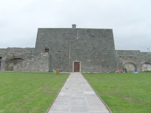
Former coastal battery, built c. 1813, comprising a two-storey blockhouse or ‘bombproof barrack’ on five-sided plan with mildly battered walls flanked by single-storey rubble stone curtain walls to the north and south (formerly with single-storey buildings to interior, now demolished), and with D-shaped traversing platform to the west (adjacent to coast) with five gun emplacements (on circular plan). Flight of external stone steps to the east elevation of two-storey barrack building giving access to doorway at first floor level. Section of rubble stone curtain wall to the south-west side of enclosure having segmental-headed carriage-arch with ashlar granite block-and-start surround, ashlar granite voussoirs with projecting keystone, projecting ashlar granite plinth blocks, and with modern timber gates. D-shaped enclosure to the east, adjacent to coast, having rubble stone boundary walls. Now in use as a heritage centre and museum. Barrel-vaulted ashlar stone roof to main barrack building having ashlar parapet walls over with rounded coping, and with modern rendered chimneystacks. Two circular gun mountings to roof. Roof reached from first floor Battered tooled coursed stone walls to main building, rubble stone to boundary and curtain walls. Square-headed gun loop openings having stayed reveals to the north and south elevations of barrack and to the west side of adjoining single-storey curtain walls. Square-headed gun loop openings to the section of curtain wall to either side of carriage-arch to the south-west. Single square-headed window openings to the north and south elevations of blockhouse having replacement timber windows. Central square-headed doorway to the east elevation of blockhouse at ground floor level having cement rendered surround, and with replacement timber door; square-headed doorway to the south end of the east elevation at first floor level having replacement timber door. Remains of rubble stone vaulted structures to the interior of enclosure to the north and south sides of blockhouse. Five former gun emplacements (on circular-plan) set along the interior of enclosure to the east side (overlooking Lough Swilly). Located to the east side of Rathmullan adjacent to the shores of Lough Swilly. Enclosure surrounded by dry moat with steep grass glacis to north-west. Sunken roadway to the west.
This official record and map point do not grant access. Most recorded buildings are privately owned; view them only from public ground unless the owner allows entry.