Add your own picture and explain the route, parking, gates, paths or landmarks that help people find it.
Earn 5 points after the picture is checked and accepted.
Add your photo and local directionsShare what you foundWhat is recorded here
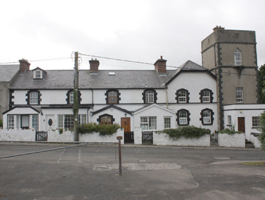
End-of-terrace former coastguard station, built 1870, comprising four terraced single-bay two-storey with attic level former coastguard houses to the north-east end, two-bay two-storey house to the south-west end of terrace, and with a single-bay three-storey observation tower (on square-plan) to the south-west elevation. Now in use as private houses with modern single-storey gable-fronted and flat-roofed additions to the north-west elevation of majority of buildings. Pitched natural slate roofs to the two houses to the north-east having red brick chimneystacks to the north-east end of each dwelling with cut stone coping and terracotta pots over; half-hipped natural slate roof to house adjoining tower; flat-roof to tower hidden behind raised rendered parapet with central loop hole opening to centre of each face (now blocked) having dressed cut stone surround. Gable-fronted dormer opening to the front pitch of roof to the dwelling to the north-east end of terrace having three-over-three pane timber sliding sash window. Remaining sections of case-iron rainwater goods. Roughcast rendered walls to dwellings having continuous dog-tooth brick sill course at first floor level, and with dressed stone block-and-start quoins with drafted margins to the corner at the north-east end; smooth rendered walls to tower with dressed stone block-and-start quoins with drafted margins to the corners, and with continuous sill course at second floor level having dog tooth brick detailing under. Projecting triangular-profile cut stone platform supported on stepped cut stone corbel to the centre of second floor of tower to the north-west and south-west elevations, overlooking Lough Swilly. Pointed shallow segmental-headed window openings at first floor level to single-bay houses, and to the ground and first floor to building adjoining tower, having dressed stone block-and-start surrounds with drafted margins, stone sills, and with some remaining six-over-six pane timber sliding sash windows and mainly replacement fittings. Triangular-headed window openings to tower at second storey level, originally doorways, having replacement fittings; square-headed window openings at first floor level having replacement fittings. Square-headed window and door openings to modern extensions having modern fittings. Set slightly back from road with rubble stone boundary wall to road-frontage to the north-west. Replacement gates. Located a short distance to the north-east of Buncrana Pier, close to the shores of Buncrana Bay, and to the south-west of the centre of Buncrana.
This official record and map point do not grant access. Most recorded buildings are privately owned; view them only from public ground unless the owner allows entry.