Add your own picture and explain the route, parking, gates, paths or landmarks that help people find it.
Earn 5 points after the picture is checked and accepted.
Add your photo and local directionsShare what you foundWhat is recorded here
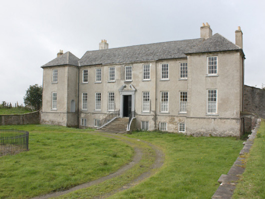
Detached nine-bay two-storey over raised basement country house, dated 1718, having central shallow advanced three-bay breakfront to the main elevation (east), advanced single-bay two-storey over raised basement projections\pavilions to either end of the main elevation (north and south), single-bay two-storey return to the rear (west), later two-bay two-storey extension to the south elevation (added c. 1860), and with handball alley to the north elevation. Pitched triple-pile stone slate roof to main body of building having concave ashlar eaves course, surviving sections of cast-iron rainwater goods, and with rendered brick chimneystacks and raised rendered verges to the gable ends (north and south); hipped stone slate roofs to advanced end bays\pavilions having concave ashlar eaves course to front elevation (east), cast-iron rainwater goods, and with rendered chimneystacks; replacement slate roof to extension to the south having red brick eaves course; hipped replacement natural slate roof to rear return. Roughcast rendered finish over rubble stone construction with raised render block quoins to the corners of advanced end bays\pavilions, smooth rendered round-headed niches to the inner faces of advanced pavilions at ground floor level, and with slightly projecting walls at basement level having natural slate coping over. Smooth rendered walls to breakfront at ground and first floor level. Brick construction to chimneybreasts. Square-headed window openings having painted cut stone sills, and with nine-over-nine pane timber sliding sash windows with exposed sash boxes at ground floor level, and six-over-six pane timber sliding sash windows at first floor level having exposed sash boxes. Square-headed window openings at basement level having replacement windows. Square-headed doorway to the centre of breakfront having timber panelled double-doors, and with cut stone doorcase having open scrolled pediment, pulvinated frieze, and pilaster strips incised ‘Anno 17’ and ‘Dom 18’. Doorway reached up sweeping staircase having moulded cut stone steps, cut stone threshold, and with flanking dwarf walls having cut stone coping and wrought-iron railings. Set back from road in own grounds to the north-west of Buncrana, located on small peninsula with Crana River to the east and Lough Swilly\Buncrana Bay to the south and west. Rubble stone boundary walls to the south and to the west of site. Terraced garden complex to the south. Sunken garden with rubble retaining walls with ashlar coping to front courtyard, with circular cast-iron railing to centre. Outbuildings (40815002) arranged around courtyard to west with high red brick boundary walls to rear. Handball alley (see 40815076) attached to the north side of house. Site bounded by rubble stone walls. Complex of walls throughout immediate vicinity of property, with former terraced garden (see 40815007) to the south-east. Earlier O’Doherty Castle (tower house, see RMP DG029-025001-) to the east. Round-plan turret-like structure to north-west of site housing a well (see 40815074). Demesne accessed by six-arch bridge (see 40815003) over Crana River to the east. Wrought-iron gates mounted on cast-iron gate posts to west side of bridge. Two main demesne entrances constituting stone gate-piers sited to east beyond former approach driveway (see 40815005) and to south-east of bridge approach (40815004). Quay to south-east (40815006). Single-storey former gate lodge (see 40815075) to the south-east, built c. 1860.
This official record and map point do not grant access. Most recorded buildings are privately owned; view them only from public ground unless the owner allows entry.