Add your own picture and explain the route, parking, gates, paths or landmarks that help people find it.
Earn 5 points after the picture is checked and accepted.
Add your photo and local directionsShare what you foundWhat is recorded here
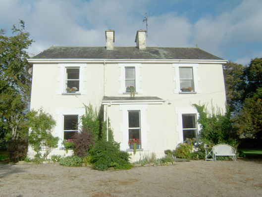
Detached three-bay two-storey Catholic parochial house, built c. 1885, with single-bay single-storey storey entrance porch to the centre of the front elevation (south-east) and single-bay two-storey return\extension to the centre of the rear elevation (north-west). Pitched natural slate roof with two central rendered chimneystacks, and with terracotta finials to gable ends. Smooth rendered walls over projecting smooth rendered plinth. Square-headed window openings with raised smooth rendered block-and-start surrounds, painted sills, and one-over-one pane timber sliding sash windows. Round-headed door opening to the north-east face of porch having raised smooth rendered block-and-start surround with keystone, timber panelled door with raised and fielded panels, and plain overlight. Set back from road in mature landscaped grounds to the south-west of Carrickart, and a short distance to the north-east of associated church (see 40808003). Detached three-bay two-storey outbuilding to the rear (north-west) having pitched natural slate roof with raised rendered verges to the gable ends, roughcast rendered walls, square-headed loading bays and doors with battened timber doors, and square-headed carriage-arches with battened timber double-doors. Partially rendered rubble stone boundary wall to the west of house (forming courtyard to rear of dwelling with outbuilding to the north-west side) having rubble stone coping over; gateway to the east giving access to rear courtyard comprising a pair of rubble stone gate piers (on square-plan having wrought-iron flat bar gate. Main gateway to site to the south of the house comprising a pair of channelled smooth rendered gate piers (on square-plan) having rendered pyramidal coping over, and with a pair of hooped wrought-iron gates; pedestrian turnstile adjacent to the west pier having wrought-iron flat-bar gate and stile. Rubble stone boundary wall to road-frontage to the south and to the south-east of site.
This official record and map point do not grant access. Most recorded buildings are privately owned; view them only from public ground unless the owner allows entry.