Add your own picture and explain the route, parking, gates, paths or landmarks that help people find it.
Earn 5 points after the picture is checked and accepted.
Add your photo and local directionsShare what you foundWhat is recorded here
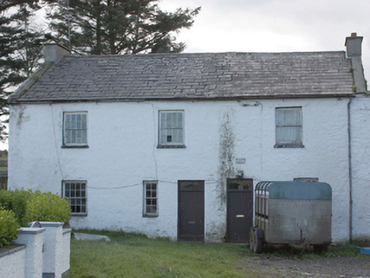
Detached three-bay two-storey former miller’s house, built c. 1780, having remains of ruinous roofless two-storey former corn mill and later as a corn\flax threshing mill with waterwheel, adjoining to the west. Pitched natural slate roof with smooth rendered chimneystacks and raised rendered verges to the gable ends (east and west), projecting eaves course, and with surviving sections of cast-iron rainwater-goods. Roughcast rendered and whitewashed random rubble stone walls. Square-headed window openings with stone sills and with eight-over-eight and three-over-three pane horned timber sliding sash windows to first floor level, and eight-over-eight and four-over-four pane timber sliding sash windows to ground floor level; assortment of timber sash and casement windows to rear. Square-headed door openings with replacement battened timber doors with plain overlights. Attached six-bay two-storey former mill building to west, now roofless, having whitewashed random rubble walls, and square-headed window and door openings having random rubble stones relieving arches over timber lintels. Two single-bay single-storey gabled projections to the north elevation of former mill having pitched natural slate (east) and pitched corrugated-metal (west) roofs, rubble stone walls, and square-headed openings. Metal breasts hot waterwheel to the west elevation of mill formerly with timber paddles, now gone. Waterwheel set in rubble stone wheel pit with round-headed arched opening to the south allowing headrace in. Former mill pond to the south, now silted up. Remains of head race to the south and tailrace to the north (flowing in and out of the Culdaff River to the west). Located at end of long approach avenue from the north-east. Located to the south of the centre of Culdaff and adjacent to the east of the Culdaff River. Possible remains of ancillary building to the south-east (not investigated).
This official record and map point do not grant access. Most recorded buildings are privately owned; view them only from public ground unless the owner allows entry.